IMAGES TAKEN NEAR TO
West View Crescent, BLACKWOOD, NP12 0JG
Introduction
This page details the photographs taken nearby to West View Crescent, NP12 0JG by members of the Geograph project.
The Geograph project started in 2005 with the aim of publishing, organising and preserving representative images for every square kilometre of Great Britain, Ireland and the Isle of Man.

There are currently over 7.5m images from over14,400 individuals and you can help contribute to the project by visiting https://www.geograph.org.uk
Image Map
Images are licensed for reuse under creativecommons.org/licenses/by-sa/2.0
Notes
- Clicking on the map will re-center to the selected point.
- The higher the marker number, the further away the image location is from the centre of the postcode.
Image Listing (75 Images Found)
Images are licensed for reuse under creativecommons.org/licenses/by-sa/2.0
Image
Details
Distance
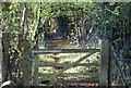
1
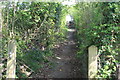
Public footpath up towards West View Crescent
Stone-paved path viewed from below gate Image, now off its hinges.
Image: © M J Roscoe
Taken: 25 Apr 2020
0.04 miles
2
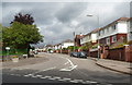
This way to the shops, Oakdale
A sign on the left points along Central Avenue towards the central shopping area.
Image: © Jaggery
Taken: 8 Aug 2012
0.06 miles
3
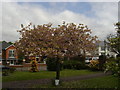
Cherry Tree, St David's Church, Oakdale
Cherry (probably Japanese) tree in grounds of church (out of sight to left); photographed as part of a survey of cherry trees, hence the clipboard at the base of the tree.
Image: © M J Roscoe
Taken: 20 May 2010
0.07 miles
4
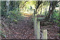
Footpath up to Oakdale
Path is a continuation of the woodland path shown in Image The small gate closes off a gap in the fences to allow movement between the fields either side of the path.
Image: © M J Roscoe
Taken: 1 Nov 2015
0.07 miles
5
Footpath down from Oakdale
An opposite view to that in Image; viewed from the track between the two fields either side of the path. The lower far end of the path is the continuation of the woodland path in Image
Image: © M J Roscoe
Taken: 1 Nov 2015
0.09 miles
6
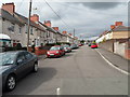
Asheville, Oakdale
The residential street Asheville climbs away from Central Avenue.
Image: © Jaggery
Taken: 8 Aug 2012
0.09 miles
7
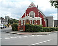
Oakdale Christian Centre
Located on the corner of Central Avenue and Kincoed Road.
Image: © Jaggery
Taken: 8 Aug 2012
0.09 miles
8
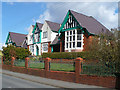
Oakdale Community Hospital
Opened in 1915.
Image: © Robin Drayton
Taken: 5 Apr 2008
0.09 miles
9
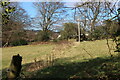
Field by footpath on hillside
Field below the former B4251 road, Oakdale. The straggly line of dead plants leads to the gateway to the next field, with houses of Rising Sun Close beyond. Viewed from gate in Image
Image: © M J Roscoe
Taken: 6 Mar 2021
0.09 miles
10
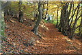
Woodland path up to Oakdale
Path leads up the hillside from a minor road, The Rhiw, to the former B4251. The wood is part of the Penmaen Woodlands Site of Importance for Nature Conservation.
Image: © M J Roscoe
Taken: 1 Nov 2015
0.10 miles