IMAGES TAKEN NEAR TO
Argoed, BLACKWOOD, NP12 0JA
Introduction
This page details the photographs taken nearby to NP12 0JA by members of the Geograph project.
The Geograph project started in 2005 with the aim of publishing, organising and preserving representative images for every square kilometre of Great Britain, Ireland and the Isle of Man.

There are currently over 7.5m images from over14,400 individuals and you can help contribute to the project by visiting https://www.geograph.org.uk
Image Map
Images are licensed for reuse under creativecommons.org/licenses/by-sa/2.0
Notes
- Clicking on the map will re-center to the selected point.
- The higher the marker number, the further away the image location is from the centre of the postcode.
Image Listing (23 Images Found)
Images are licensed for reuse under creativecommons.org/licenses/by-sa/2.0
Image
Details
Distance
1
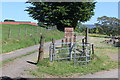
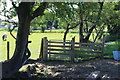
Drive to Ty'r Sais Stables, Ty'r Sais Lane
The kissing gate is the start of a public footpath from the Lane, initially on the drive, to Manmoel Road.
Image: © M J Roscoe
Taken: 29 May 2020
0.07 miles
2
Llwybr Ffarm Ty'r Sais Path
Cerddwyr yn dilyn llwybr cyhoeddus ger Ffarm Ty'r Sais.
Walkers following a public footpath near Ty'r Sais Farm (trans. Englishman's house).
Image: © Alan Richards
Taken: 16 Feb 2014
0.07 miles
3
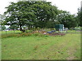
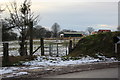
Muck pile in the corner of the paddock
In the field corner a modest muck pile is being accumulated, which will in due course I expect be spread on other fields nearby to improve them. A stables and a few ponies are off to the right of shot.
Image: © Jeremy Bolwell
Taken: 18 Jul 2011
0.08 miles
4
Gate on footpath at Ty'r Sais Stables
Decrepit wooden gate on public footpath with various obstructions beyond.
Image: © M J Roscoe
Taken: 29 May 2020
0.08 miles
5
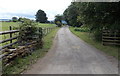
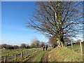
Access road to Ty'r Sais Farm
The farm buildings are about 200 metres ahead. The farm's Welsh name means Saxon's House or Englishman's House. Out of shot, a public footpath sign points along this road.
Image: © Jaggery
Taken: 13 Jul 2014
0.10 miles
6
Gate blocked by fence, Ty'r Sais Stables
A wooden fence has been erected across the metal gate on the public footpath.
Image: © M J Roscoe
Taken: 29 May 2020
0.11 miles
7
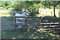
Stile on field footpath to Manmoel Road
Wooden stile leaving field next to Ty'r Sais Stables.
Image: © M J Roscoe
Taken: 29 May 2020
0.14 miles
8
Footpath towards Tywn Simon Farm, Manmoel Road
The path follows the hedge line around the field but it looks as though some people take a more direct route to the gate in a fence not shown on the map. The buildings in the background are north of Ty'r Sais Farm.
Image: © M J Roscoe
Taken: 16 Jan 2016
0.15 miles
9
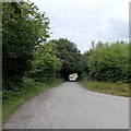
Illusion of a bridge or tunnel near Penyfan Caravan and Leisure Park
From this distance, roadside trees could be mistaken for a bridge or short tunnel.
The road is near the SW edge of the caravan and leisure park.
Image: © Jaggery
Taken: 13 Jul 2014
0.17 miles
10
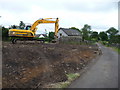
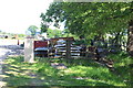
Landscaping near a barn conversion
A barn conversion has been completed here, called The Longbarn, and further groundworks are being completed in advance of either further re-development of adjacent buildings or to finish off the works already in existence. (The only problem is that the huge machine has loosened the existing dry stone walling, which on closer inspection looks perilous in places and a gate pillar is about to collapse. I'm sure it will be rectified).
Image: © Jeremy Bolwell
Taken: 18 Jul 2011
0.19 miles