IMAGES TAKEN NEAR TO
Argoed, BLACKWOOD, NP12 0HX
Introduction
This page details the photographs taken nearby to NP12 0HX by members of the Geograph project.
The Geograph project started in 2005 with the aim of publishing, organising and preserving representative images for every square kilometre of Great Britain, Ireland and the Isle of Man.

There are currently over 7.5m images from over14,400 individuals and you can help contribute to the project by visiting https://www.geograph.org.uk
Image Map
Images are licensed for reuse under creativecommons.org/licenses/by-sa/2.0
Notes
- Clicking on the map will re-center to the selected point.
- The higher the marker number, the further away the image location is from the centre of the postcode.
Image Listing (42 Images Found)
Images are licensed for reuse under creativecommons.org/licenses/by-sa/2.0
Image
Details
Distance
1
Darran Farm, Gwrhay
Viewed from junction of southerly field footpath and narrow lane.
Image: © M J Roscoe
Taken: 26 Aug 2015
0.03 miles
2
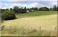
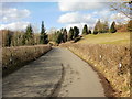
Farmland, Gwrhay
The view north from the country lane (Cwrt-y-Bella) heading from the B4251 towards Gwrhay. In the distance is Darran Farm.
Image: © Jaggery
Taken: 1 Mar 2010
0.05 miles
3
Bridleway from Darran Farm, Grwhay
The bridleway now leads to landscaped colliery waste.
Image: © M J Roscoe
Taken: 29 May 2016
0.07 miles
4
Towards Oakdale from near Darran Farm
The lane on the right leads to the B4251. The crane and steel frame of Islwyn High School can be seen in the centre background.
Image: © M J Roscoe
Taken: 15 Oct 2015
0.09 miles
5
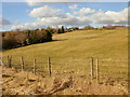
Cwrt-y-Bella, Gwrhay
The country lane (Cwrt-y-Bella) from the B4251 to Cwm-corrwg approaches Gwrhay.
Small hedges line both sides of the lane.
Image: © Jaggery
Taken: 1 Mar 2010
0.09 miles
6
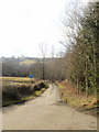
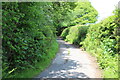
Farm lane, Gwrhay
An unnamed lane heads away from Cwrt-y-Bella towards a farmhouse.
Image: © Jaggery
Taken: 1 Mar 2010
0.09 miles
7
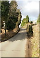
Steep climb on Cwrt-y-Bella approaching Darran Farm
The AZ South Wales Valleys East Street Atlas is very useful on walks, showing many features in addition to streets, but contours are not shown. Thus I did not know what lay ahead along Cwrt-y-Bella, from the B4251 to Gwrhay. This photo shows a steep climb along the edge of Darran Farm.
Image: © Jaggery
Taken: 1 Mar 2010
0.09 miles
8
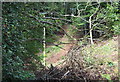
Electricity Transmission Pylons, south of Gwrhay
Two pylons in woodland
Image: © M J Roscoe
Taken: 26 Aug 2015
0.10 miles
9
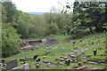
Cwrt-y-Bella Cemetery
Partly overgrown graveyard in grounds of demolished church which stood just to the right of the yew tree (right). Trees have been felled and/or fallen near an entrance.
Image: © M J Roscoe
Taken: 13 May 2020
0.12 miles
10
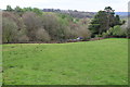
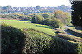
Field above Cwrt-y-bella Cemetery, Grwhay
The cemetery is the other side of the wall (centre); the yew tree (right) is on the site of the demolished church of St Philip & St James.
Image: © M J Roscoe
Taken: 20 Apr 2017
0.13 miles