IMAGES TAKEN NEAR TO
Pen-y-Fan Pond Road South, BLACKWOOD, NP12 0FD
Introduction
This page details the photographs taken nearby to Pen-y-Fan Pond Road South, NP12 0FD by members of the Geograph project.
The Geograph project started in 2005 with the aim of publishing, organising and preserving representative images for every square kilometre of Great Britain, Ireland and the Isle of Man.

There are currently over 7.5m images from over14,400 individuals and you can help contribute to the project by visiting https://www.geograph.org.uk
Image Map
Images are licensed for reuse under creativecommons.org/licenses/by-sa/2.0
Notes
- Clicking on the map will re-center to the selected point.
- The higher the marker number, the further away the image location is from the centre of the postcode.
Image Listing (40 Images Found)
Images are licensed for reuse under creativecommons.org/licenses/by-sa/2.0
Image
Details
Distance
1

Mist sprayed from top of fence
Water is sprayed from a hose pipe along the top of the fence to dampen down dust from the aggregate recycling site on the right Image Pen-y-fan Country Park is on the left of the road.
Image: © M J Roscoe
Taken: 19 Apr 2021
0.04 miles
2
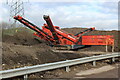
Machine sorting aggregate, The Construction Hub
Terex Finlay 674 Supertrak sorting reclaimed aggregate by size for future re-use.
Image: © M J Roscoe
Taken: 26 Feb 2021
0.05 miles
3
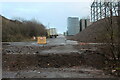
Internal road at Abingdon Floor Coverings
West end of road with new building under construction on left Image For a similar view in spring three years ago - Image
Image: © M J Roscoe
Taken: 30 Dec 2020
0.06 miles
4
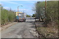
Rear of Abingdon Flooring factory site
Internal road leading to Parkway, Pen-y-fan Industrial Estate. The end of the road behind the camera is disused.
Image: © M J Roscoe
Taken: 15 Apr 2017
0.06 miles
5
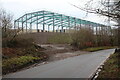
Frame for industrial building, Manmoel Road
Steel framed building under construction at rear of Abingdon Floor Coverings.
Image: © M J Roscoe
Taken: 30 Dec 2020
0.07 miles
6

Bridle path up earth bank near Pen-y-Fan Pond Country Park
Path, not shown on OS map, up a wooded low bank on the edge of landscaped colliery waste.
Image: © M J Roscoe
Taken: 15 Apr 2017
0.07 miles
7
Abingdon Floor Coverings, Pen-y-Fan Industrial Estate.
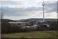
A new steel-framed building Image, in front of the wind turbine, is being roofed. The Construction Hub site is in front of the Abingdon site. Viewed from the dam wall of Pen-y-Fan Pond.
Image: © M J Roscoe
Taken: 26 Feb 2021
0.08 miles
8

Footpath through belt of trees to Manmoel Road
This public footpath passes through a belt of trees planted originally to hide a colliery waste tip sited behind the camera. The path leads to another Image on the other side of the road heading to Pen-y-fan Pond.
Image: © M J Roscoe
Taken: 5 Jun 2016
0.09 miles
9

Strip of bare ground towards solar panels
The strip of ground, stripped of grass and bushes, is where the connection to the Grid on Manmoel Road from Darran Solar Park Image in the distance is/will be buried. The strip of woodland on the right was planted to shield the then colliery waste tip to the left out of sight.
Image: © M J Roscoe
Taken: 15 Apr 2017
0.12 miles
10
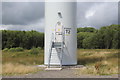
The door to wind power!
Base of wind turbine tower on Plateau 1 (reclaimed colliery waste), Oakdale Business Park. The belt of young trees in the background marks the edge of the plateau.
Image: © M J Roscoe
Taken: 20 Jul 2017
0.12 miles