IMAGES TAKEN NEAR TO
The Elms, BLACKWOOD, NP12 0EP
Introduction
This page details the photographs taken nearby to The Elms, NP12 0EP by members of the Geograph project.
The Geograph project started in 2005 with the aim of publishing, organising and preserving representative images for every square kilometre of Great Britain, Ireland and the Isle of Man.

There are currently over 7.5m images from over14,400 individuals and you can help contribute to the project by visiting https://www.geograph.org.uk
Image Map
Images are licensed for reuse under creativecommons.org/licenses/by-sa/2.0
Notes
- Clicking on the map will re-center to the selected point.
- The higher the marker number, the further away the image location is from the centre of the postcode.
Image Listing (55 Images Found)
Images are licensed for reuse under creativecommons.org/licenses/by-sa/2.0
Image
Details
Distance
1
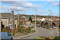
Eastern end of Waun Goch Road
A residential area in the east of Oakdale. At the end of the road the brick building with a green door is an electricity substation. On the right is the start of The Oaks road.
Image: © M J Roscoe
Taken: 27 Feb 2021
0.06 miles
2
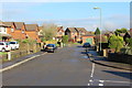
End of Waun Goch Road, Oakdale
A residential street on the west of Oakdale; taken from the junction with The Oaks. At the end of the road the low building with green doors is an electricity sub station. The road to the left of it is Prior's Gate, a cul-de-sac.
Image: © M J Roscoe
Taken: 6 Jan 2016
0.07 miles
3
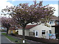
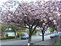
Cherry Trees, Cherry Grove, Croespenmaen
Two (probably Japanese) cherry trees, photographed for a survey of cherry trees; hence the clipboard at the base of a tree.
Image: © M J Roscoe
Taken: 13 May 2010
0.09 miles
4
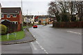
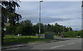
Road junctions, Croespenmaen
The traffic lights are at a crossroads on the former B4251 with the Parc Bevin Estate behind. The road to the right is Lon Maes Yr Haf leading into Croespenmaen.
Image: © M J Roscoe
Taken: 1 Jan 2016
0.10 miles
5
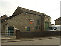
R G Davies Animal Feedstuffs & Pet Supplies, Croespenmaen
Listed Building, grade II, tithe barn, former Croespenmaen Farm, Lon Maes Yr Haf.
Image: © M J Roscoe
Taken: 23 Jul 2015
0.10 miles
6
Entry Sign -' Croespenmaen', Lon Maes Yr Haf,
Road junctions, telephone box is on Pandy Road (a cul-de-sac); behind the sign is the B4251.
Image: © M J Roscoe
Taken: 23 Jul 2015
0.11 miles
8
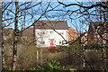
Brook Rise, Oakdale
Detached house, built this century, overlooking a public marshy green space.
Image: © M J Roscoe
Taken: 25 Mar 2016
0.12 miles
9
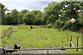
Pasture, near Brook Rise, Oakdale
Temporary fence on left.
Image: © M J Roscoe
Taken: 23 Aug 2015
0.13 miles
10
Cherry Trees, Crossfields, Croespenmaen
Probably Japanese cherry trees.
Image: © M J Roscoe
Taken: 13 May 2010
0.13 miles