IMAGES TAKEN NEAR TO
Ynys-y-Coed, BLACKWOOD, NP12 0EG
Introduction
This page details the photographs taken nearby to Ynys-y-Coed, NP12 0EG by members of the Geograph project.
The Geograph project started in 2005 with the aim of publishing, organising and preserving representative images for every square kilometre of Great Britain, Ireland and the Isle of Man.

There are currently over 7.5m images from over14,400 individuals and you can help contribute to the project by visiting https://www.geograph.org.uk
Image Map
Images are licensed for reuse under creativecommons.org/licenses/by-sa/2.0
Notes
- Clicking on the map will re-center to the selected point.
- The higher the marker number, the further away the image location is from the centre of the postcode.
Image Listing (54 Images Found)
Images are licensed for reuse under creativecommons.org/licenses/by-sa/2.0
Image
Details
Distance
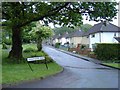
1
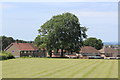
Cherry Tree, Oakdale Recreation Ground
Tree is on the edge of the small car park, overhanging the bowling green enclosure. The housing estate, then under construction, is on what were allotments.
Image: © M J Roscoe
Taken: 10 May 2010
0.05 miles
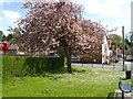
2

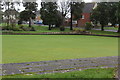
Recreation Ground, Oakdale
Edge of the sports field with the playground Image beyond, and beyond the stone wall the green pavilion.
Image: © M J Roscoe
Taken: 14 Jun 2017
0.06 miles
3
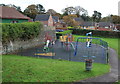
Playground, Oakdale Recreation Ground
Viewed from a ramp in the skate park. The green building on the left is the pavilion. The site is maintained by the local council.
Image: © M J Roscoe
Taken: 29 Oct 2015
0.07 miles
4
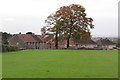
Oakdale Recreation Ground south
Edge of playing field; the houses are on Farm Close.
Image: © M J Roscoe
Taken: 29 Oct 2015
0.07 miles
5
Beech tree, rear of Farm Close, Oakdale
Beech tree, with oak tree to its left, on the edge of Oakdale Recreation Ground; see Image for an autumnal view.
Image: © M J Roscoe
Taken: 14 Jun 2017
0.07 miles
6
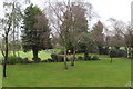
Bowling green in winter, Oakdale
Bowling green, Oakdale Recreation Ground, with Llwyn-on Lane in background.
Image: © M J Roscoe
Taken: 6 Dec 2015
0.09 miles
7
Lawn and bowling green, Oakdale
Birch and other trees in a corner of Oakdale Recreation Ground; an almost opposite view to that in Image
Image: © M J Roscoe
Taken: 6 Dec 2015
0.09 miles
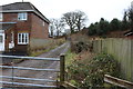
8
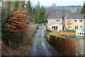
Track down from Llys-pentwyn-uchaf, Oakdale
Farm track between housing estates to Llwyn-on Lane.
Image: © M J Roscoe
Taken: 5 Feb 2016
0.11 miles
9
Track to Llys-pentwyn-uchaf, Oakdale
Farm track from Llwyn-on Lane, viewed from the gate shown in Image
Image: © M J Roscoe
Taken: 5 Feb 2016
0.13 miles