IMAGES TAKEN NEAR TO
Penmaen, BLACKWOOD, NP12 0DL
Introduction
This page details the photographs taken nearby to NP12 0DL by members of the Geograph project.
The Geograph project started in 2005 with the aim of publishing, organising and preserving representative images for every square kilometre of Great Britain, Ireland and the Isle of Man.

There are currently over 7.5m images from over14,400 individuals and you can help contribute to the project by visiting https://www.geograph.org.uk
Image Map
Images are licensed for reuse under creativecommons.org/licenses/by-sa/2.0
Notes
- Clicking on the map will re-center to the selected point.
- The higher the marker number, the further away the image location is from the centre of the postcode.
Image Listing (58 Images Found)
Images are licensed for reuse under creativecommons.org/licenses/by-sa/2.0
Image
Details
Distance
1
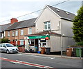
Penmaen Post Office
Located alongside Penmaen Road in number 1, Penmaen Villas.
Image: © Jaggery
Taken: 8 Aug 2012
0.01 miles
2
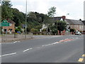
Northern boundary of Penmaen
Viewed from Oakdale. Penmaen is a village in Caerphilly county borough.
Ahead on the left is the Groveside Road junction.
Image: © Jaggery
Taken: 8 Aug 2012
0.02 miles
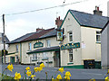
4
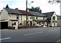
The Cross Oak Inn, Penmaen
Located alongside the main road through the village.
A notice on display in early August 2012 shows that the Cross Oak is a pub offering bed & breakfast accommodation. Lunches are available daily except Sundays and Mondays. Evening meals are available on every day of the week. There is a beer garden at the rear of the premises.
Image: © Jaggery
Taken: 8 Aug 2012
0.04 miles
5
Site of former Oakdale Comprehensive School
Part of the cleared hillside site. The school buildings, which were mostly to the right (out of shot) and down the hillside, have been demolished and the site is for sale.
Image: © M J Roscoe
Taken: 17 Jun 2019
0.04 miles
6
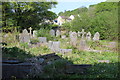
Corner of Penmaen Graveyard
The overgrown north east corner of the former chapel's graveyard; most of the gravestones appear to be Victorian. The semi-detached houses in the background are on Underwood Road.
Image: © M J Roscoe
Taken: 13 May 2016
0.04 miles
7
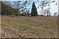
Hillside site of former Oakdale Comprehensive School
The area shown was occupied mainly by buildings; the large tree was near the main entrance.
Image: © M J Roscoe
Taken: 15 Apr 2020
0.05 miles
8
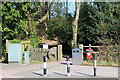
Main entrance, Roger Lewis Woodland Garden, Oakdale
The woodland once formed part of Penmaen House farm and much of it was planted in the 19th century by the farm's owner, Roger Lewis. By the 1970s only the present area remained in a deteriorated state.In 2007, with the aid of various grants, the area was improved mainly by thinning non native trees, planting many native saplings, laying a meandering path and constructing new gates. The garden was officially opened in 2008, and has since won various 'green' awards.
Image: © M J Roscoe
Taken: 14 Mar 2016
0.05 miles
9
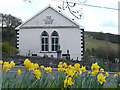
Penmain Chapel
Penmain Chapel was built in 1694, rebuilt in 1829 and renovated in 1888. The congregation that first worshipped here was established by Henry Walter http://yba.llgc.org.uk/en/s-WALT-HEN-1611.html?query=henry+walter&field=name and was one of the earliest nonconformist congregations in Wales.
Image: © Robin Drayton
Taken: 5 Apr 2008
0.06 miles
10
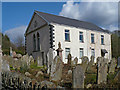
Penmain Chapel and gravestones
The chapel building is now in private ownership and is used by the Mynyddislwyn Male Voice Choir.
Image: © Robin Drayton
Taken: 5 Apr 2008
0.06 miles