IMAGES TAKEN NEAR TO
Smiths Terrace, BLACKWOOD, NP12 0BW
Introduction
This page details the photographs taken nearby to Smiths Terrace, NP12 0BW by members of the Geograph project.
The Geograph project started in 2005 with the aim of publishing, organising and preserving representative images for every square kilometre of Great Britain, Ireland and the Isle of Man.

There are currently over 7.5m images from over14,400 individuals and you can help contribute to the project by visiting https://www.geograph.org.uk
Image Map
Images are licensed for reuse under creativecommons.org/licenses/by-sa/2.0
Notes
- Clicking on the map will re-center to the selected point.
- The higher the marker number, the further away the image location is from the centre of the postcode.
Image Listing (48 Images Found)
Images are licensed for reuse under creativecommons.org/licenses/by-sa/2.0
Image
Details
Distance
1
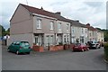
Smiths Terrace, Woodfieldside, Pontllanfraith
Viewed from the corner of New Road and Woodfield Street. http://www.geograph.org.uk/photo/3074698
Image: © Jaggery
Taken: 8 Aug 2012
0.02 miles
2
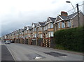
Woodfield Terrace, Pontllanfraith
A long row of houses on the east side of Woodfield Terrace in the Woodfieldside district of Pontllanfraith.
Image: © Jaggery
Taken: 8 Aug 2012
0.04 miles
3
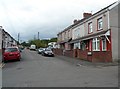
New Road houses, Woodfieldside, Pontllanfraith
Fortunately there are prominent street name signs here to minimise confusion.
The address of the houses on the right is New Road. Those on the left are in Woodfield Street.
Image: © Jaggery
Taken: 8 Aug 2012
0.04 miles
4
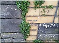
Ordnance Survey Cut Mark
This OS cut mark can be found on the wall between Nos 11 & 12 Church View. It marks a point 153.814m above mean sea level.
Image: © Adrian Dust
Taken: 9 Feb 2021
0.05 miles
5
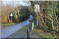
Tir Philkins, Blackwood
Minor road viewed from junction with Penmaen Road. Here the road runs alongside the Nant Philkins, just to the right out of the picture.
Image: © M J Roscoe
Taken: 2 Jan 2016
0.06 miles
6
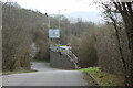
Lane beside A4048
The unnamed lane goes down to join Tir Philkins at a T-junction. The roundabout sign is for the junction of the A4048 (bypass) with the B4254 to Blackwood, to right.
Image: © M J Roscoe
Taken: 25 Mar 2023
0.07 miles
7
SE side of a Grade II listed former railway bridge, Pontllanfraith
Viewed along a lane named Tir Philkins.
http://www.geograph.org.uk/photo/3074252 to a view from the opposite side, and some details.
Image: © Jaggery
Taken: 8 Aug 2012
0.07 miles
8
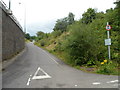
Side road alongside the A4048, Pontllanfraith
Viewed from a lane, Tir Philkins, looking north. On the left is the A4048.
Out of shot on the right is a Grade II listed bridge. http://www.geograph.org.uk/photo/3074252
Image: © Jaggery
Taken: 8 Aug 2012
0.07 miles
9
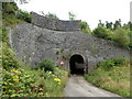
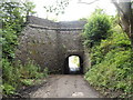
Grade II listed former railway bridge, Pontllanfraith
I was unaware of this bridge's existence, but was tempted to explore the lane named Tir-philkins by a sign on the main road showing 180 yards to a 6' 3" headroom bridge. The height of the roof at the midpoint is about 8 feet, but the 6' 3" clearance takes account of the width of a vehicle.
The bridge was built in the early 1800s to convey a horse-drawn tramway (for carrying coal) over the road. The stonework was later extended when the tramway was converted to a railway. The outline of the original smaller structure can be seen below the extension. The railway line closed in 1989.
The bridge was grade II listed in March 1999.
Image: © Jaggery
Taken: 8 Aug 2012
0.07 miles
10
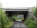
Two bridges, Tir Philkins, Pontllanfraith
Viewed along a lane named Tir Philkins. In the foreground is the bridge carrying the A4048.
Behind it is part of the stonework of a Grade II listed bridge. http://www.geograph.org.uk/photo/3074252
Image: © Jaggery
Taken: 8 Aug 2012
0.07 miles