IMAGES TAKEN NEAR TO
Bedwellty, BLACKWOOD, NP12 0BB
Introduction
This page details the photographs taken nearby to NP12 0BB by members of the Geograph project.
The Geograph project started in 2005 with the aim of publishing, organising and preserving representative images for every square kilometre of Great Britain, Ireland and the Isle of Man.

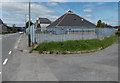
There are currently over 7.5m images from over14,400 individuals and you can help contribute to the project by visiting https://www.geograph.org.uk
Image Map
Images are licensed for reuse under creativecommons.org/licenses/by-sa/2.0
Notes
- Clicking on the map will re-center to the selected point.
- The higher the marker number, the further away the image location is from the centre of the postcode.
Image Listing (22 Images Found)
Images are licensed for reuse under creativecommons.org/licenses/by-sa/2.0
Image
Details
Distance
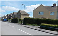
1
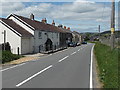
Pen-y-waun Cottages between Bedwellty and Markham
There are no boundary signs hereabouts, so these cottages are either at the northern edge of Bedwellty or the southern edge of Markham.
Image: © Jaggery
Taken: 1 Jun 2013
0.02 miles
2
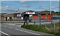
Blackwood Automotive Ltd, Markham
Located near James Street alongside the road north from Bedwellty.
The business undertakes car accident repairs and resprays, and mechanical work.
Image: © Jaggery
Taken: 1 Jun 2013
0.14 miles
3
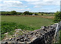
Field at the southern edge of Markham
Viewed from the road from Bedwellty. The land here is about 300 metres or nearly 1,000 feet above sea level.
Image: © Jaggery
Taken: 1 Jun 2013
0.15 miles
4
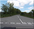
Heol Pen-Rhiw'r Eglwys, Bedwellty
The road heads east away from Bedwellty towards Argoed.
Image: © Jaggery
Taken: 1 Jun 2013
0.15 miles
5
Markham Medical Centre
Located in a pyramid-like building inside a fenced compound at the SW edge of James Street.
Image: © Jaggery
Taken: 1 Jun 2013
0.15 miles
6
New Inn Bedwellty viewed from the south
This is one of two pubs in the hamlet of Bedwellty. The other one is The Church Inn. http://www.geograph.org.uk/photo/3499721
Image: © Jaggery
Taken: 1 Jun 2013
0.18 miles
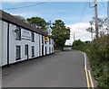
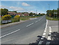
7
Road from Bedwellty to Markham
A view north past the New Inn. http://www.geograph.org.uk/photo/3503551
Image: © Jaggery
Taken: 1 Jun 2013
0.18 miles
8
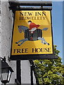
New Inn name sign Bedwellty
The style of sign hanging from a bracket here http://www.geograph.org.uk/photo/3503551 was formerly a common sight
outside Rhymney Brewery pubs. Here's a similar one. http://www.geograph.org.uk/photo/637187
Image: © Jaggery
Taken: 1 Jun 2013
0.20 miles
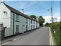
9
James Street, Markham
The houses are opposite playing fields and a school.
Image: © Jaggery
Taken: 1 Jun 2013
0.20 miles
10
Road to Markham from Aberbargoed
Viewed from the junction of Bedwellty Road. I was confused when I saw the sign on the left which at first glance seems to show 4 (miles) to Markham. I was sure that the village is much closer than that, and indeed it is, less than a mile away. The 4 on the sign is smaller than the 2 on the Bargoed sign, so the sign must originally have shown ¾.
Image: © Jaggery
Taken: 1 Jun 2013
0.20 miles