IMAGES TAKEN NEAR TO
New Road, BLACKWOOD, NP12 0AS
Introduction
This page details the photographs taken nearby to New Road, NP12 0AS by members of the Geograph project.
The Geograph project started in 2005 with the aim of publishing, organising and preserving representative images for every square kilometre of Great Britain, Ireland and the Isle of Man.

There are currently over 7.5m images from over14,400 individuals and you can help contribute to the project by visiting https://www.geograph.org.uk
Image Map
Images are licensed for reuse under creativecommons.org/licenses/by-sa/2.0
Notes
- Clicking on the map will re-center to the selected point.
- The higher the marker number, the further away the image location is from the centre of the postcode.
Image Listing (11 Images Found)
Images are licensed for reuse under creativecommons.org/licenses/by-sa/2.0
Image
Details
Distance
1
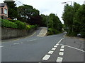
Argoed road junction
The junction of the High Street, the A4048 and the B4511 at Argoed.
Image: © Sally Lloyd
Taken: 5 Jul 2007
0.03 miles
2
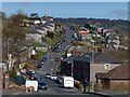
Penylan Road. Argoed
Looking north down Gelynos Avenue and then up Penylan Road (B4511) which climbs up the western side of the Sirhowy Valley towards Markham.
Image: © Robin Drayton
Taken: 1 Apr 2014
0.06 miles
3
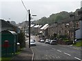
Penylan Road, Argoed
This is the B4511 from Markham as it drops down into the Sirhowy Valley on entering Argoed.
Image: © Robin Drayton
Taken: 8 Oct 2010
0.08 miles
4
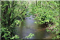
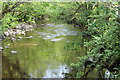
River Sirhowy, Coed Argoed
Looking down stream from same footbridge Image as inImage, all in a Site of Importance for Nature Conservation.
Image: © M J Roscoe
Taken: 28 May 2016
0.18 miles
5
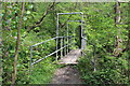
Footbridge over River Sirhowy below Argoed
An unlovely bridge with tubular railings and a concrete path bed on a public footpath; the purpose of the 'arches' is not known. The bridge links the two sides of the Coed Argoed Site of Importance for Nature Conservation.
Image: © M J Roscoe
Taken: 28 May 2016
0.19 miles
6
River Sirhowy below Argoed
Looking upstream from footbridge Image; the woodlands either side of the river are part of the Coed Argoed Site of Importance for Nature Conservation.
Image: © M J Roscoe
Taken: 28 May 2016
0.20 miles
7
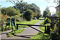
National Cycle Route 467, 'Argoed Station'
Looking south towards Blackwood at an access point near the site of the former Argoed Station. The cycle route is on the former railway trackbed, and runs parallel with the High Street, Argoed here.
Image: © M J Roscoe
Taken: 5 Oct 2016
0.21 miles
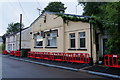
9
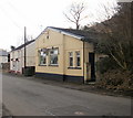
Argoed Reform Club
This is the northernmost building on High Street, which continues northwards (beyond the right edge of the photo) for about 200 metres through a wooded area before ending at the junction with the A4048.
Image: © Jaggery
Taken: 1 Mar 2010
0.22 miles
10
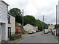
High Street, Argoed
This was once the main road through the Sirhowy Valley.
Most of the village is now bypassed by the A4048 which runs along the hillside on the left of this view.
Image: © Robin Drayton
Taken: 30 Jul 2010
0.24 miles