IMAGES TAKEN NEAR TO
Sunnyview, BLACKWOOD, NP12 0AL
Introduction
This page details the photographs taken nearby to Sunnyview, NP12 0AL by members of the Geograph project.
The Geograph project started in 2005 with the aim of publishing, organising and preserving representative images for every square kilometre of Great Britain, Ireland and the Isle of Man.

There are currently over 7.5m images from over14,400 individuals and you can help contribute to the project by visiting https://www.geograph.org.uk
Image Map
Images are licensed for reuse under creativecommons.org/licenses/by-sa/2.0
Notes
- Clicking on the map will re-center to the selected point.
- The higher the marker number, the further away the image location is from the centre of the postcode.
Image Listing (39 Images Found)
Images are licensed for reuse under creativecommons.org/licenses/by-sa/2.0
Image
Details
Distance
2
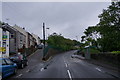
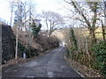
High Street Argoed climbs towards the A4048
The view up High Street from the junction with Cwm Road. Despite its name, this is
more like a country road than a high street. On the left side, the land descends steeply towards the Sirhowy valley.
http://www.geograph.org.uk/photo/1731250 to a view in the opposite direction.
Image: © Jaggery
Taken: 1 Mar 2010
0.02 miles
3
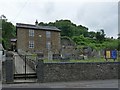
Chapel at Argoed
Chapel photographed over the green opposite Sunny View Cottages. The A4048 runs this side of the chapel but is not visible in the hollow. The High Street is beyond the chapel. Former Gospel Hall Chapel, now a private residence.
Image: © Jessica Aidley
Taken: 5 Jul 2007
0.04 miles
4
Argoed Baptist Chapel
The worn plaque on the wall of the chapel states:
ARGOED
BAPTIST CHAPEL
ERECTED A.D. 1817
RE-ERECTED 1832
Image: © Robin Drayton
Taken: 30 Jul 2010
0.04 miles
5
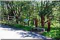
Sculptures at Quoits Wood Crossing, Argoed
Iron sculptures of three local people of note described on the adjacent bilingual notice board. They are situated at the base of the southern approach (left) to the new bridge Image for National Cycle Route 467 over the end of Cwm Road.
Image: © M J Roscoe
Taken: 5 Oct 2016
0.06 miles
6
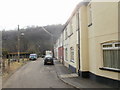
Upper James Street, Argoed
Looking down Upper James Street towards the Sirhowy river, and the steeply-rising land on the other side of the river. The distant half of the terrace is Lower James Street. http://www.geograph.org.uk/photo/1734924
Image: © Jaggery
Taken: 1 Mar 2010
0.07 miles
7
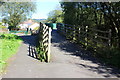
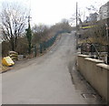
Approach to Quoits Wood Crossing, NCR 467, Argoed
Ramp on southern approach to new bridge (green railings) on National Cycle Route 467 on former railway trackbed. The bridge is higher than the original railway bridge over top of Cwm Road.
Image: © M J Roscoe
Taken: 5 Oct 2016
0.08 miles
8
Looking down the south end of High Street, Argoed
This appears to be a country road, yet it is the southern end of High Street, Argoed as it descends from the A4048. Beyond the right edge of the photo, the land descends steeply to the Sirhowy valley.
http://www.geograph.org.uk/photo/1731236 to a view from the opposite direction.
Image: © Jaggery
Taken: 1 Mar 2010
0.08 miles
9
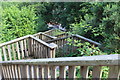
Steps to New Road, Argoed
Flight of wooden steps from small playing field down through bushes to building on New Road
Image: © M J Roscoe
Taken: 20 Jul 2016
0.08 miles
10
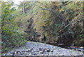
River Sirhowy below cliff, Cwm-corrwg
Looking downstream; this is probably the only cliff on the River Sirhowy.
Image: © M J Roscoe
Taken: 15 Oct 2015
0.08 miles