IMAGES TAKEN NEAR TO
Troed-y-Rhiw Road, NEWPORT, NP11 7QS
Introduction
This page details the photographs taken nearby to Troed-y-Rhiw Road, NP11 7QS by members of the Geograph project.
The Geograph project started in 2005 with the aim of publishing, organising and preserving representative images for every square kilometre of Great Britain, Ireland and the Isle of Man.

There are currently over 7.5m images from over14,400 individuals and you can help contribute to the project by visiting https://www.geograph.org.uk
Image Map
Images are licensed for reuse under creativecommons.org/licenses/by-sa/2.0
Notes
- Clicking on the map will re-center to the selected point.
- The higher the marker number, the further away the image location is from the centre of the postcode.
Image Listing (76 Images Found)
Images are licensed for reuse under creativecommons.org/licenses/by-sa/2.0
Image
Details
Distance
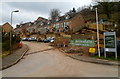
1
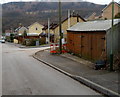
Lockup garages, Troed-y-Rhiw Road, Wattsville
On the corner of Woodside Walk. http://www.geograph.org.uk/photo/3847875
Image: © Jaggery
Taken: 16 Mar 2012
0.02 miles
2
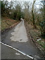
Path from Hafod Tudor Terrace to Troed-y-rhiw Road, Wattsville
The left fork here. http://www.geograph.org.uk/photo/3805999
Image: © Jaggery
Taken: 16 Mar 2012
0.03 miles
3

Junction, Troed-y-Rhiw Road, Wattsville
A side road on the left heads away from Troed-y-Rhiw Road.
Image: © Jaggery
Taken: 16 Mar 2012
0.03 miles
4
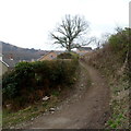
Track to Brynawel from Wattsville
The track heads south away from Troed-y-Rhiw Road, towards Brynawel.
The houses are in Woodside Walk. http://www.geograph.org.uk/photo/3847875
Image: © Jaggery
Taken: 16 Mar 2012
0.04 miles
5
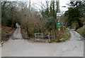
Fork in the road in Wattsville
Hafod Tudor Terrace behind the camera continues ahead on the right, leading to a track through the valley of Nant Hafod-tudur. The left fork leads to Troed-y-rhiw Road.
Image: © Jaggery
Taken: 16 Mar 2012
0.04 miles
6
Woodside Walk, Wattsville
Recently-built houses viewed from Troed-y-Rhiw Road.
Image: © Jaggery
Taken: 16 Mar 2012
0.04 miles
7
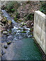
Nant Hafod-tudur, Wattsville
The stream is a tributary of the Sirhowy River, into which it flows about 350 metres away.
Image: © Jaggery
Taken: 16 Mar 2012
0.05 miles
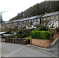
8
Prince Street houses, Wattsville
Located near Hafod Tudor Terrace on the north side of the B4251 (Nine Mile Point Road and Islwyn Road).
Image: © Jaggery
Taken: 16 Mar 2012
0.05 miles
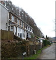
9
Hafod Tudor Terrace houses, Wattsville
Looking NW along Hafod Tudor Terrace, located on the north side of the B4251 (Nine Mile Point Road and Islwyn Road).
Image: © Jaggery
Taken: 16 Mar 2012
0.05 miles
10
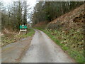
Road to Safe Haven Care & Lodges, Wattsville
If you are looking for the location in the title, the name board is reassuring.
Image: © Jaggery
Taken: 16 Mar 2012
0.07 miles