IMAGES TAKEN NEAR TO
Beechwood Avenue, NEWPORT, NP11 7QF
Introduction
This page details the photographs taken nearby to Beechwood Avenue, NP11 7QF by members of the Geograph project.
The Geograph project started in 2005 with the aim of publishing, organising and preserving representative images for every square kilometre of Great Britain, Ireland and the Isle of Man.

There are currently over 7.5m images from over14,400 individuals and you can help contribute to the project by visiting https://www.geograph.org.uk
Image Map
Images are licensed for reuse under creativecommons.org/licenses/by-sa/2.0
Notes
- Clicking on the map will re-center to the selected point.
- The higher the marker number, the further away the image location is from the centre of the postcode.
Image Listing (46 Images Found)
Images are licensed for reuse under creativecommons.org/licenses/by-sa/2.0
Image
Details
Distance
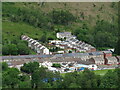
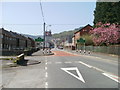
2

Beechwood Avenue, Wattsville
Viewed from the Islwyn Road end, looking towards George Street.
All the houses are on the west side of Beechwood Avenue. On the other side of the road is the perimeter wall of North Blackvein Industrial Estate.
Image: © Jaggery
Taken: 10 Apr 2011
0.03 miles
3
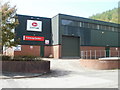
Corus Forming Centre, Wattsville
Located on the north side of Islwyn Road (A4048), to the west of Corus Colorsteels Processing Centre. http://www.geograph.org.uk/photo/429377
Image: © Jaggery
Taken: 10 Apr 2011
0.04 miles
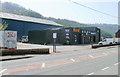
4
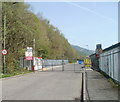
Factory entrance gates, Wattsville
Gates control the entrance to Corus Colorsteels Processing Centre http://www.geograph.org.uk/photo/429377 on the north side of Islwyn Road (A4048). A sign informs drivers that a high visibility jacket and hard hat with chin strap MUST be worn on the site.
Image: © Jaggery
Taken: 10 Apr 2011
0.04 miles
5
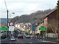
Entering Wattsville from the east
Wattsville is a late 19th century village built to house mine workers and is named after Edmund Hannay Watts who owned collieries in the area.
Image: © Robin Drayton
Taken: 13 Dec 2010
0.05 miles
6
Eastern boundary of Wattsville
Islwyn Road, from Crosskeys, approaches Wattsville, a small village in the Sirhowy valley. The village was built in the late nineteenth century to provide housing for workers in the collieries in the area. One of the collieries was the New Risca mine, formerly located nearby, where an explosion in 1880 caused 120 deaths.
Image: © Jaggery
Taken: 10 Apr 2011
0.08 miles
7
Moores Motor Repairs, Wattsville
Premises on Islwyn Road, at the eastern (Crosskeys) edge of Wattsville. The business carries out vehicle repairs, maintenance and MoT testing on cars, light commercial vehicles and motor bikes.
Image: © Jaggery
Taken: 10 Apr 2011
0.09 miles
8
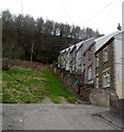
Houses up a hillside, George Street, Wattsville
Viewed from the Islwyn Road end. Steps and a handrail help residents and visitors ascend and descend the steep slope.
Image: © Jaggery
Taken: 16 Mar 2012
0.09 miles
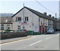
9

New look for the Jubilee Bar & Event Room, Wattsville
Located on the corner of Woodland View and Islwyn Road (B4251).
Since this http://www.geograph.org.uk/photo/2380521 view in April 2011, green has become the main exterior colour.
Image: © Jaggery
Taken: 16 Mar 2012
0.12 miles
10
Jubilee, Wattsville
Since this view http://www.geograph.org.uk/photo/1891106 taken the previous year, the Jubilee Club on Islwyn Road has been renamed Jubilee Bar and Event Room. Large signs proclaim the attractions available, such as real ales, log fire and 150 seat function room.
Update Here's http://www.geograph.org.uk/photo/2852042 how the premises looked in March 2012.
Image: © Jaggery
Taken: 10 Apr 2011
0.12 miles