IMAGES TAKEN NEAR TO
Newport Road, NEWPORT, NP11 7LU
Introduction
This page details the photographs taken nearby to Newport Road, NP11 7LU by members of the Geograph project.
The Geograph project started in 2005 with the aim of publishing, organising and preserving representative images for every square kilometre of Great Britain, Ireland and the Isle of Man.

There are currently over 7.5m images from over14,400 individuals and you can help contribute to the project by visiting https://www.geograph.org.uk
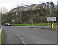
Image Map
Images are licensed for reuse under creativecommons.org/licenses/by-sa/2.0
Notes
- Clicking on the map will re-center to the selected point.
- The higher the marker number, the further away the image location is from the centre of the postcode.
Image Listing (146 Images Found)
Images are licensed for reuse under creativecommons.org/licenses/by-sa/2.0
Image
Details
Distance
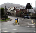
1
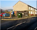
Newport Road telecomms cabinet, Cwmcarn
Viewed across the B4591 Newport Road in late December 2016.
A notice on the cabinet states that fibre broadband is here.
Image: © Jaggery
Taken: 29 Dec 2016
0.02 miles
2
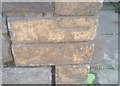
Ordnance Survey Cut Mark
This OS cut mark can be found on the wall of NO5 Twyncarn Terrace. It marks a point 91.483m above mean sea level.
Image: © Adrian Dust
Taken: 11 May 2019
0.03 miles
3
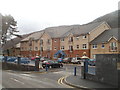
Cwrt Twyncarn, Cwmcarn
Built in 2009, Cwrt Twyncarn contains 32 1- and 2-bedroom apartments for people aged at least 55. Located on the west side of Newport Road (B4591).
Image: © Jaggery
Taken: 7 Feb 2011
0.03 miles
4
A467 directions sign, Cwmcarn
Facing southbound traffic on the A467 on the approach to this roundabout. http://www.geograph.org.uk/photo/5236574
Image: © Jaggery
Taken: 20 Dec 2016
0.04 miles
5
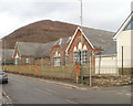
Cwmcarn Primary School
Viewed across Newport Road (B4591).
Image: © Jaggery
Taken: 7 Feb 2011
0.04 miles
6
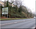
Road towards the centre of Cwmcarn
The B4591 Newport Road ascends into Cwmcarn.
Beyond the car on the corner of Feeder Row, the speed limit drops to 20mph.
The road on the lower left leads to the A467 which bypasses most of Cwmcarn.
Image: © Jaggery
Taken: 20 Dec 2016
0.04 miles
7
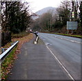
Gap in the roadside barrier, Cwmcarn
On the west side of the A467. Abercarn is ahead.
Image: © Jaggery
Taken: 20 Dec 2016
0.04 miles
8

Centregreat van with a Versalift, Newport Road, Cwmcarn
The van has a Versalift, an access platform which can be extended for working high above street level, such as on street lights.
Image: © Jaggery
Taken: 29 Dec 2016
0.05 miles
9
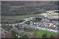
Cwmcarn from above (2)
Viewed from a high point on Cwmcarn Forest Drive, the long row of terraced houses next to the playing field is Feeder Row Image The Raven Walk runs alongside the playing field.
Image: © M J Roscoe
Taken: 31 Mar 2017
0.05 miles
10
A467 direction sign, Cwmcarn
This way for Brynmawr, Ebbw Vale, Tredegar, Blackwood.
Image: © Jaggery
Taken: 20 Dec 2016
0.05 miles