IMAGES TAKEN NEAR TO
Cwmfelinfach, Ynysddu, NEWPORT, NP11 7JE
Introduction
This page details the photographs taken nearby to NP11 7JE by members of the Geograph project.
The Geograph project started in 2005 with the aim of publishing, organising and preserving representative images for every square kilometre of Great Britain, Ireland and the Isle of Man.

There are currently over 7.5m images from over14,400 individuals and you can help contribute to the project by visiting https://www.geograph.org.uk
Image Map
Images are licensed for reuse under creativecommons.org/licenses/by-sa/2.0
Notes
- Clicking on the map will re-center to the selected point.
- The higher the marker number, the further away the image location is from the centre of the postcode.
Image Listing (58 Images Found)
Images are licensed for reuse under creativecommons.org/licenses/by-sa/2.0
Image
Details
Distance
1
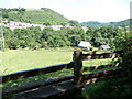
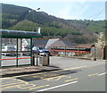
Part of the Sirhowy Valley
Part of Cwmfelinfach from the Sirhowy Valley Walk on a hot July day.
Image: © Jeremy Bolwell
Taken: 26 Jul 2011
0.07 miles
2
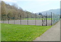
Tennis court, Nine Mile Point Welfare Grounds
Nine Mile Point Welfare Grounds are located in the Sirhowy Valley between Ynysddu and Cwmfelinfach.
Image: © Jaggery
Taken: 7 Apr 2011
0.08 miles
3
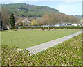
Bowling green, Nine Mile Point Welfare Grounds
Nine Mile Point Welfare Grounds are located in the Sirhowy Valley between Ynysddu and Cwmfelinfach.
Image: © Jaggery
Taken: 7 Apr 2011
0.08 miles
4
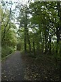
Dense woodland by track in Sirhowy Valley Country Park
Image: © David Smith
Taken: 27 Sep 2021
0.09 miles
5
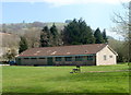
Sports pavilion, Nine Mile Point Welfare Grounds
Nine Mile Point Welfare Grounds are located in the Sirhowy Valley between Ynysddu and Cwmfelinfach.
Image: © Jaggery
Taken: 7 Apr 2011
0.10 miles
6
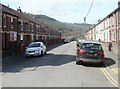
Commercial Buildings, Cwmfelinfach
The incongruously named Commercial Buildings are a row of 11 houses on Commercial Road, which is itself incongruously named, for in 2012 there are no commercial premises in Commercial Road.
Image: © Jaggery
Taken: 14 Mar 2012
0.13 miles
7
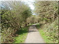
Path along western edge of Cwmfelinfach
The path heads towards Ynysddu through the Sirhowy valley. Its course is at a slightly lower elevation than the central residential area of Cwmfelinfach.
Image: © Jaggery
Taken: 7 Apr 2011
0.13 miles
8
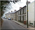
King Street Cwmfelinfach
Viewed from Western Terrace. King Street is a 115 metre long cul-de-sac with about 40 houses.
Image: © Jaggery
Taken: 7 Apr 2011
0.13 miles
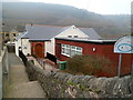
9
Cwmfelinfach Community Church
Accessed by a path from a bus stop on Maindee Road, the church (and flat-roofed church hall in front) are set below street level.
Image: © Jaggery
Taken: 7 Apr 2011
0.13 miles
10
Cwmfelinfach Community Church
Accessed by a path from a bus stop on Maindee Road, the church (and flat-roofed church hall in front) are set below street level.
Image: © Jaggery
Taken: 14 Mar 2012
0.13 miles