IMAGES TAKEN NEAR TO
Commercial Road, NEWPORT, NP11 7HW
Introduction
This page details the photographs taken nearby to Commercial Road, NP11 7HW by members of the Geograph project.
The Geograph project started in 2005 with the aim of publishing, organising and preserving representative images for every square kilometre of Great Britain, Ireland and the Isle of Man.

There are currently over 7.5m images from over14,400 individuals and you can help contribute to the project by visiting https://www.geograph.org.uk
Image Map
Images are licensed for reuse under creativecommons.org/licenses/by-sa/2.0
Notes
- Clicking on the map will re-center to the selected point.
- The higher the marker number, the further away the image location is from the centre of the postcode.
Image Listing (82 Images Found)
Images are licensed for reuse under creativecommons.org/licenses/by-sa/2.0
Image
Details
Distance
1
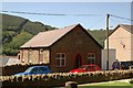
Bethany Presbyterian Chapel Cwmfelinfach
This chapel was founded in 1912 but is now used as private accommodation.
Image: © Peter Hutchings
Taken: 15 Jul 2004
0.01 miles
2
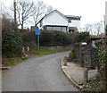
Unsuitable for HGVs, Twyn Gwyn Road, Cwmfelinfach
The road ahead is narrow, steep and bendy. Though there is no letter V in the Welsh alphabet, the Welsh for HGVs shown on the blue sign is the same as in English.
Image: © Jaggery
Taken: 14 Mar 2012
0.03 miles
3
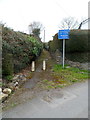
Short cut, Twyn Gwyn Road, Cwmfelinfach
Two concrete posts are at the start of a 35-metre short cut giving walkers a safer
alternative to using a sharp bend in the course of narrow, pavementless Twyn Gwyn Road.
The Unsuitable for HGVs sign of course refers to the roadway!
Image: © Jaggery
Taken: 14 Mar 2012
0.03 miles
4
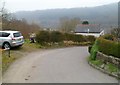
Bend in Twyn Gwyn Road, Cwmfelinfach
Walkers can avoid this potentially dangerous section of road (no pavements) by using a short cut.http://www.geograph.org.uk/photo/2849121
Image: © Jaggery
Taken: 14 Mar 2012
0.03 miles
5
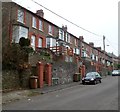
Firbank Terrace Cwmfelinfach viewed from the NW
Firbank Terrace is a row of 12 houses on the north side of Commercial Road,
facing Commercial Buildings. http://www.geograph.org.uk/photo/2848968
Image: © Jaggery
Taken: 14 Mar 2012
0.03 miles
6
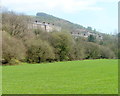
Cwmfelinfach houses viewed from Nine Mile Point Welfare Grounds
Houses in Commercial Road and Maindee Road, Cwmfelinfach viewed from Nine Mile Point Welfare Grounds which are located in the Sirhowy Valley between Ynysddu and Cwmfelinfach.
Image: © Jaggery
Taken: 7 Apr 2011
0.03 miles
7
Maindee Road houses,Cwmfelinfach
Houses on the NE side of the B4251. The white-on-green street name signs on the pavement show Pioneer Terrace http://www.geograph.org.uk/photo/2384981 to the left, Maindee Road to the right.
Image: © Jaggery
Taken: 7 Apr 2011
0.03 miles
8
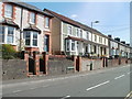
Newer Commercial Road houses, Cwmfelinfach
These houses appear to have been built several decades after most of the rest of the houses in Commercial Road.
Image: © Jaggery
Taken: 14 Mar 2012
0.03 miles
9
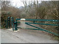
Metal barrier across a path, Cwmfelinfach
The barrier at the edge of Twyn Gwyn Road prevents anything wider than the narrow entrance on the left from accessing a path http://www.geograph.org.uk/photo/2849096 into woods.
Image: © Jaggery
Taken: 14 Mar 2012
0.07 miles
10
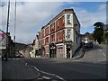
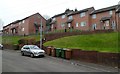
Maindee Road (A4048), Cwmfelinfach
The name Cwmfelinfach comes from a small flannel mill that once stood close to the river.
The building at the road junction is Coronation Buildings named after the coronation of King Edward VII in 1902.
There was also a nearby Coronation Colliery http://www.geograph.org.uk/photo/1797090 .
Image: © Robin Drayton
Taken: 7 Apr 2010
0.07 miles