IMAGES TAKEN NEAR TO
Commercial Road, NEWPORT, NP11 7HN
Introduction
This page details the photographs taken nearby to Commercial Road, NP11 7HN by members of the Geograph project.
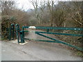
The Geograph project started in 2005 with the aim of publishing, organising and preserving representative images for every square kilometre of Great Britain, Ireland and the Isle of Man.

There are currently over 7.5m images from over14,400 individuals and you can help contribute to the project by visiting https://www.geograph.org.uk
Image Map
Images are licensed for reuse under creativecommons.org/licenses/by-sa/2.0
Notes
- Clicking on the map will re-center to the selected point.
- The higher the marker number, the further away the image location is from the centre of the postcode.
Image Listing (78 Images Found)
Images are licensed for reuse under creativecommons.org/licenses/by-sa/2.0
Image
Details
Distance
1

Information Board, Cwmfelinfach
Historical information provided as part of the Loops and Links project.
Image: © Robin Drayton
Taken: 7 Apr 2010
0.02 miles
2
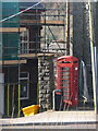
Cwmfelinfach: phone box and grit bin
A closer look at the telephone box standing outside Image
Image: © Chris Downer
Taken: 1 Mar 2014
0.03 miles
3
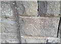
Ordnance Survey Cut Mark
This OS cut mark can be found on the stone post at the Pioneer Hotel. It marks a point 112.709m above mean sea level.
Image: © Adrian Dust
Taken: 23 Jun 2021
0.03 miles
4
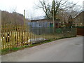
Electricity substation, Cwmfelinfach
Located at the southern end of Twyn Gwyn Road, near the Commercial Road junction.
Image: © Jaggery
Taken: 14 Mar 2012
0.04 miles
5
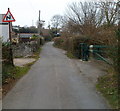
Bends ahead, Twyn Gwyn Road, Cwmfelinfach
A sign warns of bends ahead. On the right is a barrier http://www.geograph.org.uk/photo/2849102 at the edge of a path into woods.
Image: © Jaggery
Taken: 14 Mar 2012
0.04 miles
6
Metal barrier across a path, Cwmfelinfach
The barrier at the edge of Twyn Gwyn Road prevents anything wider than the narrow entrance on the left from accessing a path http://www.geograph.org.uk/photo/2849096 into woods.
Image: © Jaggery
Taken: 14 Mar 2012
0.04 miles
7
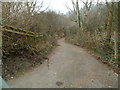
Path into woodland, Cwmfelinfach
A path heads away from a barrier on the east side of Twyn Gwyn Road.
Image: © Jaggery
Taken: 14 Mar 2012
0.04 miles
8
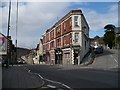
Maindee Road (A4048), Cwmfelinfach
The name Cwmfelinfach comes from a small flannel mill that once stood close to the river.
The building at the road junction is Coronation Buildings named after the coronation of King Edward VII in 1902.
There was also a nearby Coronation Colliery http://www.geograph.org.uk/photo/1797090 .
Image: © Robin Drayton
Taken: 7 Apr 2010
0.04 miles
9
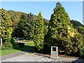
Memorial Gardens, Cwmfelinfach
The detail of the memorial can be seen here http://www.geograph.org.uk/photo/1575082 .
Image: © Robin Drayton
Taken: 14 Oct 2009
0.04 miles
10
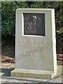
War Memorial, Cwmfelinfach
A general memorial depicting personnel of the three services.
Image: © Robin Drayton
Taken: 14 Oct 2009
0.04 miles