IMAGES TAKEN NEAR TO
Western Terrace, NEWPORT, NP11 7HJ
Introduction
This page details the photographs taken nearby to Western Terrace, NP11 7HJ by members of the Geograph project.
The Geograph project started in 2005 with the aim of publishing, organising and preserving representative images for every square kilometre of Great Britain, Ireland and the Isle of Man.

There are currently over 7.5m images from over14,400 individuals and you can help contribute to the project by visiting https://www.geograph.org.uk
Image Map
Images are licensed for reuse under creativecommons.org/licenses/by-sa/2.0
Notes
- Clicking on the map will re-center to the selected point.
- The higher the marker number, the further away the image location is from the centre of the postcode.
Image Listing (88 Images Found)
Images are licensed for reuse under creativecommons.org/licenses/by-sa/2.0
Image
Details
Distance
1
Fenced-off building, Cwmfelinfach
This was formerly the Pioneer Hotel, opposite Coronation Buildings. http://www.geograph.org.uk/photo/2835329 The Pioneer closed in 2007.
Image: © Jaggery
Taken: 7 Apr 2011
0.03 miles
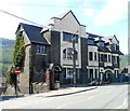
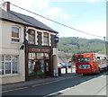
2
Coronation Buildings, Cwmfelinfach
Located on the corner of Maindee Road and Commercial Road. An inscription in stone above the doorway of the corner premises shows BANK. There were no banks left in Cwmfelinfach at the date of this view (April 2011).
Image: © Jaggery
Taken: 7 Apr 2011
0.03 miles
3
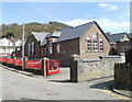
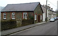
Cwmfelinfach Primary School
Viewed across Western Terrace. Children from Cwmfelinfach and Wattsville attend the school.
Engraved in stone above the large twin white windows near the middle of the view is
CWMFELIN-FACH COUNCIL SCHOOL BUILT 1909.
Image: © Jaggery
Taken: 7 Apr 2011
0.03 miles
4
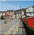
NE end of Western Terrace, Cwmfelinfach
The view from near the corner of King Street http://www.geograph.org.uk/photo/2385081 along Western Terrace towards Maindee Road (B4251). Maindee Road is shown on older maps as the A4048.
The railings are at the perimeter of Cwmfelinfach Primary School. http://www.geograph.org.uk/photo/2385074
Image: © Jaggery
Taken: 7 Apr 2011
0.04 miles
5
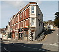
Celtic Print, Cwmfelinfach
The business at 20 Maindee Road provides a full custom framing service as well as canvas, acrylic and photographic prints. A Stagecoach bus on service 56 from Newport, is on its way to Tredegar via Blackwood.
Image: © Jaggery
Taken: 7 Apr 2011
0.04 miles
6
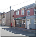
Cwmfelinfach post office
Located at 11 Maindee Road.
Image: © Jaggery
Taken: 7 Apr 2011
0.04 miles
7
Cwmfelinfach Police Station
The small police station (on the right) at 37 Maindee Road is part of Gwent Police.
Image: © Jaggery
Taken: 7 Apr 2011
0.04 miles
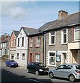
8
Commercial Road semis, Cwmfelinfach
These semi-detached houses have names but no house numbers. Most of the other houses in Commercial Road are in rows, and have numbers but no names.
Image: © Jaggery
Taken: 14 Mar 2012
0.04 miles
9
Former Bethany Chapel, Cwmfelinfach
Now a private residence, 20 Commercial Road, the building was formerly Bethany Chapel, built in 1912.
Image: © Jaggery
Taken: 14 Mar 2012
0.04 miles
10
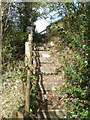
Steps from footpath to Western Terrace, Cwmfelinfach
Rough steps connect a footpath http://www.geograph.org.uk/photo/2385055 http://www.geograph.org.uk/photo/2385051 with Western Terrace. http://www.geograph.org.uk/photo/2385036
Image: © Jaggery
Taken: 7 Apr 2011
0.05 miles