IMAGES TAKEN NEAR TO
Glannant Street, NEWPORT, NP11 7HB
Introduction
This page details the photographs taken nearby to Glannant Street, NP11 7HB by members of the Geograph project.
The Geograph project started in 2005 with the aim of publishing, organising and preserving representative images for every square kilometre of Great Britain, Ireland and the Isle of Man.

There are currently over 7.5m images from over14,400 individuals and you can help contribute to the project by visiting https://www.geograph.org.uk
Image Map
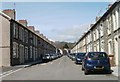
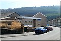
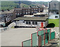
Images are licensed for reuse under creativecommons.org/licenses/by-sa/2.0
Notes
- Clicking on the map will re-center to the selected point.
- The higher the marker number, the further away the image location is from the centre of the postcode.
Image Listing (80 Images Found)
Images are licensed for reuse under creativecommons.org/licenses/by-sa/2.0
Image
Details
Distance
1
Islwyn Street, Cwmfelinfach
Looking north towards New Road (B4251).
Image: © Jaggery
Taken: 7 Apr 2011
0.04 miles
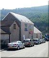
2
Forestier & Walkers Club, Cwmfelinfach
Conservative club, Islwyn Street. Various online references give the name as "Forestier Walker" but the nameboard shows Forestier & Walkers Club.
Image: © Jaggery
Taken: 7 Apr 2011
0.04 miles
3
Cwmfelinfach Community Hall
Viewed from Islwyn Street.
Image: © Jaggery
Taken: 7 Apr 2011
0.04 miles
4
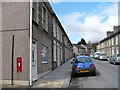
Islwyn Street
Islwyn was the bardic name of the minister of a nearby chapel http://www.geograph.org.uk/photo/1810038 .
Note the Victorian wall postbox.
Image: © Robin Drayton
Taken: 7 Apr 2010
0.05 miles
5
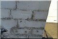
Ordnance Survey Cut Mark
This OS cut mark can be found on No1 Mill Street. It marks a point 100.121m above mean sea level.
Image: © Adrian Dust
Taken: 23 Jun 2021
0.05 miles
6
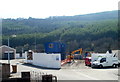
Construction of Oak Grove houses, Cwmfelinfach
This April 2011 view from the corner of Stanley Street shows work in progress on the building of new houses at a development named Oak Grove.
Image: © Jaggery
Taken: 7 Apr 2011
0.06 miles
7
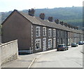
Stanley Street, Cwmfelinfach
Houses on the east side of the street.
Image: © Jaggery
Taken: 7 Apr 2011
0.06 miles
8
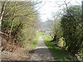
Footpath between Mill Street and Penllwyn Street, Cwmfelinfach
The view SE along an area of greenery, towards a children's play area.
Image: © Jaggery
Taken: 7 Apr 2011
0.06 miles
9
Upsa-Daisy, Cwmfelinfach
Day nursery on Stanley Street, facing Mill Street.
Image: © Jaggery
Taken: 7 Apr 2011
0.06 miles
10
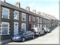
Mill Street, Cwmfelinfach
Houses on the west side of the street viewed from the Stanley Street end.
Image: © Jaggery
Taken: 7 Apr 2011
0.06 miles