1
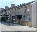
Melin Street,Cwmfelinfach
Looking north towards New Road (B4251).
Image: © Jaggery
Taken: 7 Apr 2011
0.01 miles
2
Islwyn Street
Islwyn was the bardic name of the minister of a nearby chapel http://www.geograph.org.uk/photo/1810038 .
Note the Victorian wall postbox.
Image: © Robin Drayton
Taken: 7 Apr 2010
0.04 miles
3
Cwmfelinfach Workmen's Club & Institute
Located at 1-2 Hill View, on the corner of Melin Street.
Image: © Jaggery
Taken: 7 Apr 2011
0.05 miles
4
Lane to Tyn-y-graig, Cwmfelinfach
Viewed from Melin Street across New Road (B4251). An unnamed lane passing the right side of the row of houses heads towards a hillside house named Tyn-y-graig. http://www.geograph.org.uk/photo/2835451
Image: © Jaggery
Taken: 7 Apr 2011
0.05 miles
5
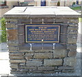
Plaque recording the site of Nine Mile Point Colliery Workmen's Institute, Cwmfelinfach
The plaque is in the residential cul-de-sac Nine Mile Point Court. http://www.geograph.org.uk/photo/2836830
Image: © Jaggery
Taken: 7 Apr 2011
0.05 miles
6
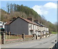
Nine Mile Point Court houses, Cwmfelinfach
The houses are set back from the west side of Melin Street.
A plaque http://www.geograph.org.uk/photo/2836836 records that this was the site of Nine Mile Point Colliery Workmen's Institute.
Image: © Jaggery
Taken: 7 Apr 2011
0.05 miles
7
New Road houses, Cwmfelinfach
The row of houses on the NE side of New Road (B4251) is between the turnings for Islwyn Street and Melin Street.
Image: © Jaggery
Taken: 7 Apr 2011
0.05 miles
8
Cwmfelinfach seen from Ynyshowell
This shows a partial view of Cwmfelinfach with the road to Twyn Gwyn (upper right) and part of the village of Ynysddu in the distance. The photograph was take from near the visitor centre of Ynyshowell where Neil Kinnock spent the night before his abortive attempt to become Prime Minister in the 1990s.
Image: © Peter Hutchings
Taken: 15 Jul 2004
0.06 miles
9
Babell Chapel
A side view of the chapel showing the entrance door just behind the right hand pillar.
The hillside in the background is part of the Sirhowy Valley Country Park.
Image: © Robin Drayton
Taken: 7 Apr 2010
0.06 miles
10
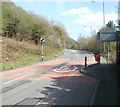
Eastern edge of Cwmfelinfach
The speed limit on the B4251 increases from 30mph to the National Speed Limit beyond the eastern boundary http://www.geograph.org.uk/photo/2836892 of Cwmfelinfach.
Image: © Jaggery
Taken: 7 Apr 2011
0.07 miles


