IMAGES TAKEN NEAR TO
Arthur Street, NEWPORT, NP11 7GX
Introduction
This page details the photographs taken nearby to Arthur Street, NP11 7GX by members of the Geograph project.
The Geograph project started in 2005 with the aim of publishing, organising and preserving representative images for every square kilometre of Great Britain, Ireland and the Isle of Man.

There are currently over 7.5m images from over14,400 individuals and you can help contribute to the project by visiting https://www.geograph.org.uk
Image Map
Images are licensed for reuse under creativecommons.org/licenses/by-sa/2.0
Notes
- Clicking on the map will re-center to the selected point.
- The higher the marker number, the further away the image location is from the centre of the postcode.
Image Listing (71 Images Found)
Images are licensed for reuse under creativecommons.org/licenses/by-sa/2.0
Image
Details
Distance
1
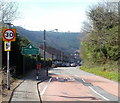
Eastern boundary of Cwmfelinfach
The B4251 reaches Cwmfelinfach, a village in the Sirhowy valley.
Image: © Jaggery
Taken: 7 Apr 2011
0.04 miles
2
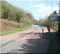
Eastern edge of Cwmfelinfach
The speed limit on the B4251 increases from 30mph to the National Speed Limit beyond the eastern boundary http://www.geograph.org.uk/photo/2836892 of Cwmfelinfach.
Image: © Jaggery
Taken: 7 Apr 2011
0.04 miles
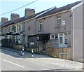
4
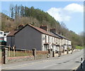
New Road houses, Cwmfelinfach
The row of houses on the NE side of New Road (B4251) is between the turnings for Islwyn Street and Melin Street.
Image: © Jaggery
Taken: 7 Apr 2011
0.05 miles
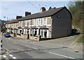
5
Cwmfelinfach Workmen's Club & Institute
Located at 1-2 Hill View, on the corner of Melin Street.
Image: © Jaggery
Taken: 7 Apr 2011
0.05 miles
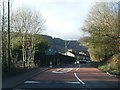
6
Lane to Tyn-y-graig, Cwmfelinfach
Viewed from Melin Street across New Road (B4251). An unnamed lane passing the right side of the row of houses heads towards a hillside house named Tyn-y-graig. http://www.geograph.org.uk/photo/2835451
Image: © Jaggery
Taken: 7 Apr 2011
0.05 miles
7
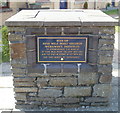
Plaque recording the site of Nine Mile Point Colliery Workmen's Institute, Cwmfelinfach
The plaque is in the residential cul-de-sac Nine Mile Point Court. http://www.geograph.org.uk/photo/2836830
Image: © Jaggery
Taken: 7 Apr 2011
0.05 miles
8
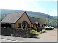
Nine Mile Point Court houses, Cwmfelinfach
The houses are set back from the west side of Melin Street.
A plaque http://www.geograph.org.uk/photo/2836836 records that this was the site of Nine Mile Point Colliery Workmen's Institute.
Image: © Jaggery
Taken: 7 Apr 2011
0.05 miles
9
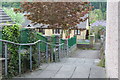
Path to Nine Mile Court, Cwmfelinfach
Stepped path from New Road down to a group of small bungalows Image
Image: © M J Roscoe
Taken: 6 May 2017
0.06 miles
10
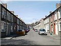
Melin Street,Cwmfelinfach
Looking north towards New Road (B4251).
Image: © Jaggery
Taken: 7 Apr 2011
0.06 miles