IMAGES TAKEN NEAR TO
George Street, NEWPORT, NP11 7ES
Introduction
This page details the photographs taken nearby to George Street, NP11 7ES by members of the Geograph project.
The Geograph project started in 2005 with the aim of publishing, organising and preserving representative images for every square kilometre of Great Britain, Ireland and the Isle of Man.

There are currently over 7.5m images from over14,400 individuals and you can help contribute to the project by visiting https://www.geograph.org.uk
Image Map
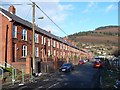
Images are licensed for reuse under creativecommons.org/licenses/by-sa/2.0
Notes
- Clicking on the map will re-center to the selected point.
- The higher the marker number, the further away the image location is from the centre of the postcode.
Image Listing (106 Images Found)
Images are licensed for reuse under creativecommons.org/licenses/by-sa/2.0
Image
Details
Distance
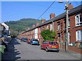
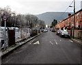
2
Nantcarn Road, Cwmcarn
The houses are opposite allotments on a bank of Nant Carn, a tributary of the Ebbw River.
Image: © Jaggery
Taken: 29 Dec 2016
0.03 miles
3
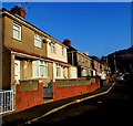
Tribute Avenue semis, Cwmcarn
The semi-detached houses face the backs of George Street houses.
Image: © Jaggery
Taken: 29 Dec 2016
0.03 miles
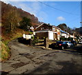
4
A back lane in Cwmcarn
Below the backs of George Street houses, viewed from the top of these http://www.geograph.org.uk/photo/5244682 steps.
Image: © Jaggery
Taken: 29 Dec 2016
0.04 miles
5
Nantcarn Road speed bump, Cwmcarn
In a 20mph maximum speed zone.
Image: © Jaggery
Taken: 29 Dec 2016
0.04 miles
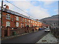
6
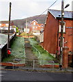
Steps up from Nantcarn Road, Cwmcarn
Ascending for 25 metres towards a lane at the back of houses in George Street and Park Street.
Image: © Jaggery
Taken: 29 Dec 2016
0.05 miles
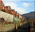
7
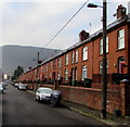
Long row of houses, Nantcarn Road, Cwmcarn
This is one of two long rows of Nantcarn Road houses. Both rows extend for about 135 metres,
opposite allotments http://www.geograph.org.uk/photo/5244582 on a bank of Nant Carn, a tributary of the Ebbw River.
Image: © Jaggery
Taken: 29 Dec 2016
0.05 miles
8
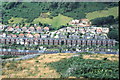
View of Nantcarn Road, Cwmcarn
Photo taken from Cwmcarn Forest Drive
Image: © Darius Khan
Taken: 10 Aug 2002
0.05 miles
9
Nant Carn Road
This was the route to Cwmcarn Visitor Centre when the usual route was closed because of ice.
For a completely different view of this road see http://www.geograph.org.uk/photo/89411 .
Image: © Robin Drayton
Taken: 7 Feb 2009
0.05 miles
10
Side road above Upper Tribute Avenue, Cwmcarn
Viewed from the eastern end of Tribute Avenue. The road on the right is Upper Tribute Avenue.
There is no name sign on the road ascending from the junction, nor is it named on maps I've consulted.
Image: © Jaggery
Taken: 29 Dec 2016
0.05 miles