IMAGES TAKEN NEAR TO
Brooklands Terrace, NEWPORT, NP11 7EA
Introduction
This page details the photographs taken nearby to Brooklands Terrace, NP11 7EA by members of the Geograph project.
The Geograph project started in 2005 with the aim of publishing, organising and preserving representative images for every square kilometre of Great Britain, Ireland and the Isle of Man.

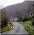
There are currently over 7.5m images from over14,400 individuals and you can help contribute to the project by visiting https://www.geograph.org.uk
Image Map
Images are licensed for reuse under creativecommons.org/licenses/by-sa/2.0
Notes
- Clicking on the map will re-center to the selected point.
- The higher the marker number, the further away the image location is from the centre of the postcode.
Image Listing (141 Images Found)
Images are licensed for reuse under creativecommons.org/licenses/by-sa/2.0
Image
Details
Distance
1
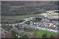
Cwmcarn from above (2)
Viewed from a high point on Cwmcarn Forest Drive, the long row of terraced houses next to the playing field is Feeder Row Image The Raven Walk runs alongside the playing field.
Image: © M J Roscoe
Taken: 31 Mar 2017
0.04 miles
2
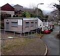
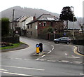
Cwmcarn Paragon Cycling Club clubhouse
The cycling club's single-storey clubhouse is on the corner of Brooklands and the B4591 Twyncarn Road.
Founded in 1932, the club moved here in 1976. New members are welcome.
http://www.geograph.org.uk/photo/5235600 to the name sign.
Image: © Jaggery
Taken: 20 Dec 2016
0.04 miles
3
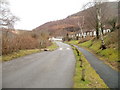
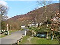
Southern section of Cwmcarn Forest Drive
Cwmcarn Forest Drive and a footpath head past North Road houses towards the forest.
Image: © Jaggery
Taken: 7 Feb 2011
0.05 miles
4
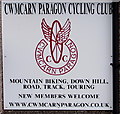
Cwmcarn Paragon Cycling Club name sign
On the wall here. http://www.geograph.org.uk/photo/5235594
Image: © Jaggery
Taken: 20 Dec 2016
0.05 miles
5
Speed bump on Cwmcarn Forest Drive
Painted white triangles draw attention to the speed bump alongside a 15mph speed limit sign.
Image: © Jaggery
Taken: 20 Dec 2016
0.05 miles
6
Entrance to Cwm Carn Scenic Drive
This was once the railway track up to Cwmcarn Colliery.
Image: © Robin Drayton
Taken: 8 Feb 2008
0.05 miles
7
Road towards the centre of Cwmcarn
The B4591 Newport Road ascends into Cwmcarn.
Beyond the car on the corner of Feeder Row, the speed limit drops to 20mph.
The road on the lower left leads to the A467 which bypasses most of Cwmcarn.
Image: © Jaggery
Taken: 20 Dec 2016
0.05 miles
8

B4591 junction at the southern edge of Cwmcarn
On the right, the B4591 Twyncarn Road heads towards central Cwmcarn.
The road to the left heads towards the A467.
Image: © Jaggery
Taken: 22 Jun 2018
0.05 miles
9
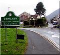
Southern boundary of Cwmcarn
Facing Pontywaun, the sign is alongside the B4591 Twyncarn Road.
The Pontywaun boundary sign http://www.geograph.org.uk/photo/5235585 is on the back of this one.
Both villages are in Caerphilly County Borough.
Image: © Jaggery
Taken: 20 Dec 2016
0.05 miles
10
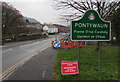
Northern boundary of Pontywaun
Facing Cwmcarn, the sign is alongside the B4591 Twyncarn Road.
The Cwmcarn boundary sign http://www.geograph.org.uk/photo/5235580 is on the back of this one.
Both villages are in Caerphilly County Borough.
Image: © Jaggery
Taken: 20 Dec 2016
0.05 miles