IMAGES TAKEN NEAR TO
Pandy View, NEWPORT, NP11 7DL
Introduction
This page details the photographs taken nearby to Pandy View, NP11 7DL by members of the Geograph project.
The Geograph project started in 2005 with the aim of publishing, organising and preserving representative images for every square kilometre of Great Britain, Ireland and the Isle of Man.

There are currently over 7.5m images from over14,400 individuals and you can help contribute to the project by visiting https://www.geograph.org.uk
Image Map
Images are licensed for reuse under creativecommons.org/licenses/by-sa/2.0
Notes
- Clicking on the map will re-center to the selected point.
- The higher the marker number, the further away the image location is from the centre of the postcode.
Image Listing (242 Images Found)
Images are licensed for reuse under creativecommons.org/licenses/by-sa/2.0
Image
Details
Distance
1
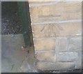
Ordnance Survey Cut Mark
This OS cut mark can be found on the wall of a house, south side of the road. It marks a point 73.609m above mean sea level.
Image: © Adrian Dust
Taken: 11 May 2019
0.02 miles
2
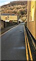
No parking in Pandy View, Crosskeys
Double yellow lines on both sides of the narrow
one-way road indicate no parking at any time.
Image: © Jaggery
Taken: 20 Dec 2022
0.02 miles
3
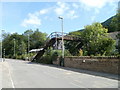
Disused railway footbridge, High Street, Crosskeys
A sign on metal railings now blocking the entrance to the footbridge states
Bridge closed. Please use level crossing.
Level crossing is something of a misnomer - it is actually a track-level wooden bridge. http://www.geograph.org.uk/photo/2262176
Image: © Jaggery
Taken: 16 Aug 2010
0.02 miles
4
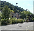
Hall's Road, Crosskeys
Houses on Hall's Road viewed from High Street across a railway line. The footbridge is no longer in use.
Image: © Jaggery
Taken: 16 Aug 2010
0.02 miles
6

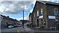
Darren Morgan Sports shop, 26 High Street, Crosskeys
The inscription on the pediment is THE RISCA & CROSSKEYS CO-OPERATIVE SOCIETY.
Image: © Jaggery
Taken: 17 Dec 2016
0.04 miles
7
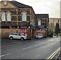
DMSports, High Street, Crosskeys
Sportswear and sporting goods shop on the corner of Beecher Terrace.
Image: © Jaggery
Taken: 20 Dec 2022
0.04 miles
8
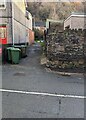
Wheelie bins in an alleyway, Crosskeys
On the east side of the B4591 High Street.
Image: © Jaggery
Taken: 20 Dec 2022
0.04 miles
9
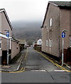
Pandy View, Crosskeys
One way street on the west side of High Street. Double yellow lines on both sides indicate no parking at any time.
Image: © Jaggery
Taken: 17 Dec 2016
0.04 miles
10
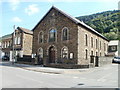
Hope Baptist Church, Crosskeys
Located on the corner of High Street and Oak Terrace.
The foundation stone was laid in 1880. The church opened as Hope English Baptist Chapel. Services were conducted in English, in an era when Welsh was the predominant language in the area.
Image: © Jaggery
Taken: 16 Aug 2010
0.04 miles