IMAGES TAKEN NEAR TO
Park View, NEWPORT, NP11 7DE
Introduction
This page details the photographs taken nearby to Park View, NP11 7DE by members of the Geograph project.
The Geograph project started in 2005 with the aim of publishing, organising and preserving representative images for every square kilometre of Great Britain, Ireland and the Isle of Man.

There are currently over 7.5m images from over14,400 individuals and you can help contribute to the project by visiting https://www.geograph.org.uk
Image Map
Images are licensed for reuse under creativecommons.org/licenses/by-sa/2.0
Notes
- Clicking on the map will re-center to the selected point.
- The higher the marker number, the further away the image location is from the centre of the postcode.
Image Listing (124 Images Found)
Images are licensed for reuse under creativecommons.org/licenses/by-sa/2.0
Image
Details
Distance
1
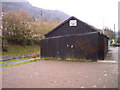
Pontywaun Spiritualist Church
A corrugated iron church beside the Crumlin Branch of the Brecon and Monmouth Canal
Image: © nantcoly
Taken: 9 Dec 2005
0.01 miles
2
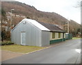
Pontywaun Spiritualist Church
Located on the bank of the disused Monmouthshire & Brecon canal. The church has been rebuilt after a fire in 2006. This http://www.geograph.org.uk/photo/88844 is how it looked in 2005.
Image: © Jaggery
Taken: 7 Feb 2011
0.01 miles
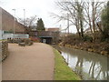
3
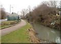
Disused Monmouthshire & Brecon canal, Pontywaun
The view north. The building is Pontywaun Spiritualist Church. http://www.geograph.org.uk/photo/2262367
Image: © Jaggery
Taken: 7 Feb 2011
0.01 miles
4
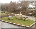
Canalside sculpture, Pontywaun
Located alongside the disused Monmouthshire & Brecon Canal. It depicts a pit winding wheel and several buildings in a boat, probably symbolising the wealth the canal brought to the area by giving a route for the transport of coal and iron, especially in the days before the arrival of the railways.
The Monmouthshire & Brecon canal was authorised by Act of Parliament in 1792.
Image: © Jaggery
Taken: 7 Feb 2011
0.01 miles
5
Canal bridge, Pontywaun
A bridge carries the B4591 above the disused Monmouthshire & Brecon canal.
Image: © Jaggery
Taken: 7 Feb 2011
0.01 miles
6
Northern end of Halls Road Terrace, Pontywaun
Looking towards Pontywaun Spiritualist Church http://www.geograph.org.uk/photo/2262367 from the edge of the B4591.
That's not an optical illusion causing a distortion in the metal fences on the left, but elaborate patterns.
Image: © Jaggery
Taken: 7 Feb 2011
0.01 miles
7
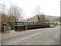
Tubewrights footbridge Pontywaun
The footbridge is alongside the B4591 road bridge http://www.geograph.org.uk/photo/2307970 on the Crosskeys/Pontywaun border.
It was built by Tubewrights of Newport (known as Newport (Mon) at the time).
There are similar bridges of this distinctive design elsewhere. http://www.geograph.org.uk/photo/1865483 http://www.geograph.org.uk/photo/1508407 http://www.geograph.org.uk/photo/2279963
Image: © Jaggery
Taken: 7 Feb 2011
0.01 miles
8
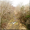
Track along bed of dismantled railway line, Pontywaun
Viewed from the B4591 footbridge. http://www.geograph.org.uk/photo/2307972
Image: © Jaggery
Taken: 7 Feb 2011
0.01 miles
9
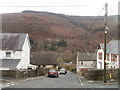
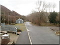
The view down Trinity Hill, Pontywaun
Viewed from the junction of Gelli-unig Road and Garden Suburbs.
Image: © Jaggery
Taken: 7 Feb 2011
0.01 miles
10
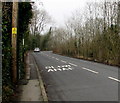
SLOW/ARAF on High Street, Crosskeys
The bilingual (English/Welsh) SLOW/ARAF is painted on the B4591 High Street
on the approach to a bend in the road at the southern edge of Pontywaun.
Image: © Jaggery
Taken: 17 Dec 2016
0.03 miles