IMAGES TAKEN NEAR TO
Fields Park Terrace, NEWPORT, NP11 7DA
Introduction
This page details the photographs taken nearby to Fields Park Terrace, NP11 7DA by members of the Geograph project.
The Geograph project started in 2005 with the aim of publishing, organising and preserving representative images for every square kilometre of Great Britain, Ireland and the Isle of Man.

There are currently over 7.5m images from over14,400 individuals and you can help contribute to the project by visiting https://www.geograph.org.uk
Image Map
Images are licensed for reuse under creativecommons.org/licenses/by-sa/2.0
Notes
- Clicking on the map will re-center to the selected point.
- The higher the marker number, the further away the image location is from the centre of the postcode.
Image Listing (222 Images Found)
Images are licensed for reuse under creativecommons.org/licenses/by-sa/2.0
Image
Details
Distance
1
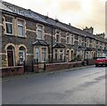
Row of stone houses, Fields Park Terrace, Crosskeys
On the left here. https://www.geograph.org.uk/photo/7365643
Image: © Jaggery
Taken: 20 Dec 2022
0.01 miles
2
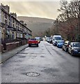
SSW along Fields Park Terrace, Crosskeys
From the corner of Park Place. Fields Park Terrace leads to Pandy View and Western Terrace.
Image: © Jaggery
Taken: 20 Dec 2022
0.03 miles
3
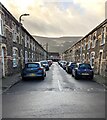
South along Park Street, Crosskeys
From Park Place along Park Street towards Pandy View.
Image: © Jaggery
Taken: 20 Dec 2022
0.03 miles
4
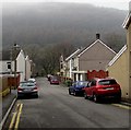
West along Park Place, Crosskeys
Park Place descends from High Street.
Image: © Jaggery
Taken: 17 Dec 2016
0.03 miles
5
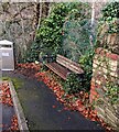
Bench on a Crosskeys corner
On the corner of Park Place and Fields Park Terrace.
Image: © Jaggery
Taken: 20 Dec 2022
0.03 miles
6
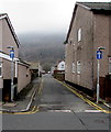
Pandy View, Crosskeys
One way street on the west side of High Street. Double yellow lines on both sides indicate no parking at any time.
Image: © Jaggery
Taken: 17 Dec 2016
0.04 miles
7
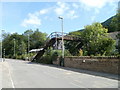
Disused railway footbridge, High Street, Crosskeys
A sign on metal railings now blocking the entrance to the footbridge states
Bridge closed. Please use level crossing.
Level crossing is something of a misnomer - it is actually a track-level wooden bridge. http://www.geograph.org.uk/photo/2262176
Image: © Jaggery
Taken: 16 Aug 2010
0.04 miles
8
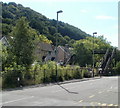
Hall's Road, Crosskeys
Houses on Hall's Road viewed from High Street across a railway line. The footbridge is no longer in use.
Image: © Jaggery
Taken: 16 Aug 2010
0.04 miles
9
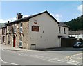
Eagle Inn, Crosskeys
On the corner of High Street and Park Place.
Image: © Jaggery
Taken: 16 Aug 2010
0.04 miles
10
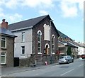
Crosskeys Methodist Church
Located on High Street, a few metres north of Park Place. The church dates from 1875.
Image: © Jaggery
Taken: 16 Aug 2010
0.04 miles