IMAGES TAKEN NEAR TO
High Street, NEWPORT, NP11 7BY
Introduction
This page details the photographs taken nearby to High Street, NP11 7BY by members of the Geograph project.
The Geograph project started in 2005 with the aim of publishing, organising and preserving representative images for every square kilometre of Great Britain, Ireland and the Isle of Man.

There are currently over 7.5m images from over14,400 individuals and you can help contribute to the project by visiting https://www.geograph.org.uk
Image Map
Images are licensed for reuse under creativecommons.org/licenses/by-sa/2.0
Notes
- Clicking on the map will re-center to the selected point.
- The higher the marker number, the further away the image location is from the centre of the postcode.
Image Listing (229 Images Found)
Images are licensed for reuse under creativecommons.org/licenses/by-sa/2.0
Image
Details
Distance
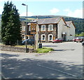
1
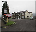
Solar Strand hotel & restaurant, Crosskeys
Set back from the east side of High Street, viewed in December 2016.
This building was the Cross Keys pub http://www.geograph.org.uk/photo/2016434 in 2010.
Image: © Jaggery
Taken: 17 Dec 2016
0.00 miles
2
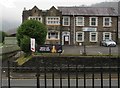
Solar Strand hotel & restaurant, Crosskeys
Viewed across High Street from Carlton Terrace in December 2016.
This building was the Cross Keys pub http://www.geograph.org.uk/photo/2016434 in 2010.
Image: © Jaggery
Taken: 17 Dec 2016
0.00 miles
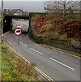
4
Vehicle length restriction sign facing High Street, Crosskeys
The sign on the corner of the access road to Carlton Terrace and
Crosskeys railway station shows a maximum vehicle length of 19' 8".
Image: © Jaggery
Taken: 17 Dec 2016
0.02 miles
5
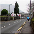
Jogging up High Street, Crosskeys
Wearing a turquoise top and black trousers, a Saturday jogger ascends High Street.
Image: © Jaggery
Taken: 17 Dec 2016
0.02 miles
6
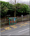
High Street bus stop and shelter near Crosskeys railway station
This side of the road for buses towards Blackwood and Ebbw Vale.
Image: © Jaggery
Taken: 17 Dec 2016
0.03 miles
7
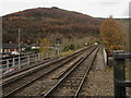
Railway from Crosskeys towards Newbridge
Viewed from Crosskeys station looking across the High Street bridge.
In the distance, the two tracks merge into one track.
Image: © Jaggery
Taken: 20 Nov 2019
0.03 miles
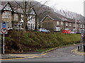
8
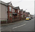
Carlton Terrace, Crosskeys
From the corner of Oak Terrace. Carlton Terrace leads to Carlton Place.
Image: © Jaggery
Taken: 17 Dec 2016
0.03 miles
9
Weight limit sign facing High Street, Crosskeys
In the UK, red-edged circular signs indicate a prohibition. This one shows no vehicles heavier than 7.5 tonnes.
Image: © Jaggery
Taken: 17 Dec 2016
0.04 miles
10
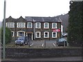
The Cross Keys, High Street, Crosskeys
Pub with accommodation available, located on High Street opposite Carlton Terrace.
The village of Crosskeys (population c3000) was originally named Pont-y-cymer.
Image: © Jaggery
Taken: 16 Aug 2010
0.04 miles