IMAGES TAKEN NEAR TO
Cotswold Way, NEWPORT, NP11 6RG
Introduction
This page details the photographs taken nearby to Cotswold Way, NP11 6RG by members of the Geograph project.
The Geograph project started in 2005 with the aim of publishing, organising and preserving representative images for every square kilometre of Great Britain, Ireland and the Isle of Man.

There are currently over 7.5m images from over14,400 individuals and you can help contribute to the project by visiting https://www.geograph.org.uk
Image Map
Images are licensed for reuse under creativecommons.org/licenses/by-sa/2.0
Notes
- Clicking on the map will re-center to the selected point.
- The higher the marker number, the further away the image location is from the centre of the postcode.
Image Listing (25 Images Found)
Images are licensed for reuse under creativecommons.org/licenses/by-sa/2.0
Image
Details
Distance
1
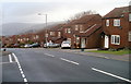
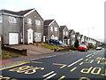
Northern edge of Cotswold Way, Risca
The view west along Cotswold Way past the junction with Cheviot Close.
Viewed from one of the highest points in residential Risca, at nearly 200 metres above sea level. The lowest residential elevations in Risca are about 40 metres above sea level, in the vicinity of the Ebbw River.
Houses behind the camera are of a different type. http://www.geograph.org.uk/photo/2232147
Image: © Jaggery
Taken: 14 Jan 2011
0.04 miles
2
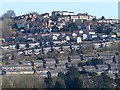
Ty-Sign, Risca
A housing estate, built in the 1960s, that overlooks Risca.
Viewed from the Dan-y-graig cemetery http://www.geograph.org.uk/photo/4845710 which is the other side of the valley.
Image: © Robin Drayton
Taken: 24 Feb 2016
0.06 miles
4
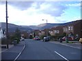
Risca: looking up Cotswold Way from the corner of Pentland Close
The steepness of the land in this area is shown by this view from the corner of Pentland Close. http://www.geograph.org.uk/photo/2232174
Image: © Jaggery
Taken: 14 Jan 2011
0.15 miles
5
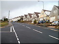
Detached houses, Cotswold Way, Risca
The view SE along houses on the northern side of Cotswold Way. Houses behind the camera are of a different type. http://www.geograph.org.uk/photo/2232138
Image: © Jaggery
Taken: 14 Jan 2011
0.15 miles
6
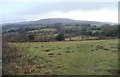
The view from Cotswold Way, Risca towards Twmbarlwm
The view NW from an open space just north of Cotswold Way, Risca, looking towards the mounded peak of Twmbarlwm Image on a dull, mild day in mid January.
Image: © Jaggery
Taken: 14 Jan 2011
0.16 miles
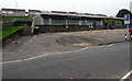
7
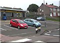
Alco Minimarket, Risca
Premier convenience store at 275-277 Elm Drive.
Image: © Jaggery
Taken: 26 Jun 2019
0.17 miles
9
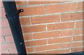
Ordnance Survey Cut Mark
This OS cut mark can be found on the junction between Nos285/287 Elm Drive. It marks a point 134.540m above mean sea level.
Image: © Adrian Dust
Taken: 11 May 2019
0.17 miles
10
Tŷ Jade, Risca
Tŷ Jade Chinese takeaway on the left is at 269 Elm Drive, Risca.
Image: © Jaggery
Taken: 26 Jun 2019
0.18 miles