IMAGES TAKEN NEAR TO
Risca, NEWPORT, NP11 6LE
Introduction
This page details the photographs taken nearby to NP11 6LE by members of the Geograph project.
The Geograph project started in 2005 with the aim of publishing, organising and preserving representative images for every square kilometre of Great Britain, Ireland and the Isle of Man.

There are currently over 7.5m images from over14,400 individuals and you can help contribute to the project by visiting https://www.geograph.org.uk
Image Map
Images are licensed for reuse under creativecommons.org/licenses/by-sa/2.0
Notes
- Clicking on the map will re-center to the selected point.
- The higher the marker number, the further away the image location is from the centre of the postcode.
Image Listing (126 Images Found)
Images are licensed for reuse under creativecommons.org/licenses/by-sa/2.0
Image
Details
Distance
1
West along Foundry Road, Risca
The sign on the right shows that Foundry Road leads to Millbrook Cottages.
The sign on the left shows that Foundry Road is Heol y Ffowndri in Welsh.
Image: © Jaggery
Taken: 22 Nov 2018
0.02 miles
2
BT phonebox, Foundry Road, Risca
Near the corner of Lower Wyndham Terrace.
Image: © Jaggery
Taken: 22 Nov 2018
0.02 miles
3
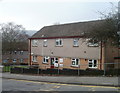
Hafod-y-Bryn, Risca
This building, located on Lower Wyndham Terrace, Risca, contains one flat, the communal area and the warden's office of Hafod-y-Bryn, an area of 29 1-bedroom or 2-bedroom flats, built in 1968. There is a community alarm service and non-resident management staff. Hafod-y-Bryn is managed by Caerphilly County Borough Council Housing Services.
Image: © Jaggery
Taken: 17 Feb 2011
0.02 miles
4
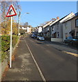
Warning sign - elderly people, Lower Wyndham Terrace, Risca
On the left here. https://www.geograph.org.uk/photo/5984825
Image: © Jaggery
Taken: 22 Nov 2018
0.02 miles
5

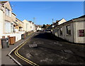
Crossroads mini-roundabout in Risca
In the middle of the crossroads of Mill Street, Foundry Road, Channel View and Lower Wyndham Terrace.
Image: © Jaggery
Taken: 22 Nov 2018
0.03 miles
6
Up Mill Street, Pontymister
Mill Street ascends towards Foundry Road and Channel View.
The Masons Arms pub https://www.geograph.org.uk/photo/5758342 is near the camera.
Image: © Jaggery
Taken: 1 May 2018
0.03 miles
7
Northern end of Mill Street, Risca
Mill Street ascends towards crossroads at the junctions of Foundry Road, Channel View and Lower Wyndham Terrace. Double yellow lines indicate no parking at any time.
Image: © Jaggery
Taken: 22 Nov 2018
0.03 miles
8
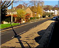
Two-tone road surface, Lower Wyndham Terrace, Risca
On the ascent towards the Ty Sign area of Risca.
Image: © Jaggery
Taken: 22 Nov 2018
0.04 miles
9
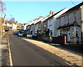
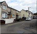
Lower Wyndham Terrace semis, Risca
Semi-detached houses on the east side of Lower Wyndham Terrace,
on the ascent towards the Ty Sign area of Risca.
Image: © Jaggery
Taken: 22 Nov 2018
0.04 miles