IMAGES TAKEN NEAR TO
Channel View, NEWPORT, NP11 6JW
Introduction
This page details the photographs taken nearby to Channel View, NP11 6JW by members of the Geograph project.
The Geograph project started in 2005 with the aim of publishing, organising and preserving representative images for every square kilometre of Great Britain, Ireland and the Isle of Man.

There are currently over 7.5m images from over14,400 individuals and you can help contribute to the project by visiting https://www.geograph.org.uk
Image Map
Images are licensed for reuse under creativecommons.org/licenses/by-sa/2.0
Notes
- Clicking on the map will re-center to the selected point.
- The higher the marker number, the further away the image location is from the centre of the postcode.
Image Listing (97 Images Found)
Images are licensed for reuse under creativecommons.org/licenses/by-sa/2.0
Image
Details
Distance
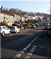
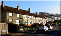
1
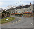
Severn Close, Risca
It's often unclear exactly where Pontymister ends and Risca begins. Some sources state that Severn Close is in Risca, others say Pontymister. It's possible that both are correct, for Severn Close fans out in a V-shaped pattern from Channel View. Houses 1-26 are along the left (west) arm of the close, part of which is seen here. Houses 27-38 are beyond the right edge of the photo.
Image: © Jaggery
Taken: 11 Mar 2010
0.05 miles
2
Severn Close in Risca
Viewed across the road named Channel View. The back gardens of
these houses are alongside the Monmouthshire & Brecon Canal.
Image: © Jaggery
Taken: 22 Nov 2018
0.06 miles
3
Looking down Channel View, Pontymister
Viewed from opposite the turning for Severn Close.
Image: © Jaggery
Taken: 11 Mar 2010
0.06 miles
4
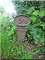
Milestone, Crumlin Branch of the MonBrec
On the MonBrec canal Crumlin branch. Milepost / mile peg dates from the days of the Monmouth Canal Company. Grade II listed see CADW https://cadwpublic-api.azurewebsites.net/reports/listedbuilding/FullReport?lang=&id=87787
Inscription: 5 ½
Milestone Society National ID: CRU-05½
Image: © Mr Red
Taken: 10 Jun 2021
0.06 miles
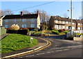
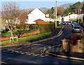
5
Up Channel View, Risca
Channel View ascends away from the Cwrt Golw y Sianel junction.
Image: © Jaggery
Taken: 22 Nov 2018
0.07 miles
6
Severn Close bus stop and shelter, Risca
Located near Severn Close and Machen Close, this stop on
Channel View is for buses to the centre of Risca via Ty Sign.
Image: © Jaggery
Taken: 22 Nov 2018
0.07 miles
7
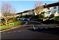
Junction of Machen Close and Channel View, Risca
Viewed across the road named Channel View.
Image: © Jaggery
Taken: 22 Nov 2018
0.08 miles
8
Machen Close, Risca
On the north side of Channel View.
Image: © Jaggery
Taken: 22 Nov 2018
0.10 miles
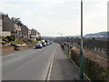
9
Channel View houses, Risca
Channel View houses with a view of the Bristol Channel from windows on this side.
Image: © Jaggery
Taken: 22 Nov 2018
0.10 miles
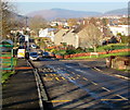
10
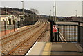
The view east from Risca and Pontymister railway station
Viewed from platform 2.
On the left is the Masons Arms pub. http://www.geograph.org.uk/photo/1749442 On the right is part of the parking area. The blue markings on the road surface visible through the vertical bars of the railings designate the area reserved for disabled parking badge holders.
Image: © Jaggery
Taken: 11 Mar 2010
0.11 miles