IMAGES TAKEN NEAR TO
St. Mary Street, NEWPORT, NP11 6GU
Introduction
This page details the photographs taken nearby to St. Mary Street, NP11 6GU by members of the Geograph project.
The Geograph project started in 2005 with the aim of publishing, organising and preserving representative images for every square kilometre of Great Britain, Ireland and the Isle of Man.

There are currently over 7.5m images from over14,400 individuals and you can help contribute to the project by visiting https://www.geograph.org.uk
Image Map
Images are licensed for reuse under creativecommons.org/licenses/by-sa/2.0
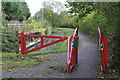
Notes
- Clicking on the map will re-center to the selected point.
- The higher the marker number, the further away the image location is from the centre of the postcode.
Image Listing (151 Images Found)
Images are licensed for reuse under creativecommons.org/licenses/by-sa/2.0
Image
Details
Distance
1
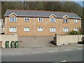
Madison Gardens, Risca
Flats on the NE side of St Mary Street (B4591).
Image: © Jaggery
Taken: 10 Apr 2011
0.01 miles
2
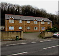
Madison Gardens, Risca
Flats set back from the B4591 St Mary Street.
Image: © Jaggery
Taken: 10 Jan 2017
0.01 miles
3
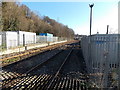
Towards Risca & Pontymister railway station from Lime Kiln level crossing, Risca
Viewed looking SE from here. http://www.geograph.org.uk/photo/1759011 The station is nearly 2km ahead.
Image: © Jaggery
Taken: 11 Jan 2014
0.02 miles
4
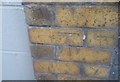
Ordnance Survey Cut Mark
This OS cut mark can be found on the wall of No4 St Mary Street. It marks a point 53.093m above mean sea level.
Image: © Adrian Dust
Taken: 11 May 2019
0.04 miles
5
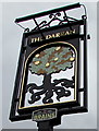
The Darran name sign, Risca
On a post outside this http://www.geograph.org.uk/photo/5249596 pub. The stylised depiction of an oak led me to the obvious conclusion that darran is Welsh for oak. I was wrong. The Welsh for oak is derwen. Perhaps darran is a local variant of derwen...
Image: © Jaggery
Taken: 10 Jan 2017
0.04 miles
6
Red phonebox on a Risca corner
On the corner of St Mary Street and Grove Road, in front of the Good Buy Shop.
Image: © Jaggery
Taken: 10 Jan 2017
0.04 miles
7
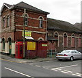
Lloyds Pharmacy, Risca
The St Mary Street side of the pharmacy near Risca Surgery in Ravenswood Court.
Image: © Jaggery
Taken: 10 Jan 2017
0.05 miles
8
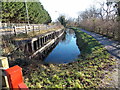
Disused canal alongside Darran Road, Risca
Viewed from here. http://www.geograph.org.uk/photo/3813647 This was a working canal from the end of the 18th century until the 1940s, part of the Crumlin Arm of the Monmouthshire & Brecon Canal. The towpath on the right is now a footpath and cycleway.
Image: © Jaggery
Taken: 11 Jan 2014
0.05 miles
9
Monmouthshire & Brecon Canal alongside Darran Road
Disused section of canal's Crumlin Arm. This section ends at a culvert below the metal gate.
Image: © M J Roscoe
Taken: 20 Oct 2017
0.05 miles
10
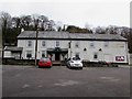
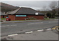
The Darran, Risca
Recently refurbished Brains brewery pub set back from St Mary Street, viewed in January 2017.
http://www.geograph.org.uk/photo/5249596 to a side view.
Image: © Jaggery
Taken: 10 Jan 2017
0.06 miles