IMAGES TAKEN NEAR TO
St. Mary Street, NEWPORT, NP11 6GG
Introduction
This page details the photographs taken nearby to St. Mary Street, NP11 6GG by members of the Geograph project.
The Geograph project started in 2005 with the aim of publishing, organising and preserving representative images for every square kilometre of Great Britain, Ireland and the Isle of Man.

There are currently over 7.5m images from over14,400 individuals and you can help contribute to the project by visiting https://www.geograph.org.uk
Image Map
Images are licensed for reuse under creativecommons.org/licenses/by-sa/2.0
Notes
- Clicking on the map will re-center to the selected point.
- The higher the marker number, the further away the image location is from the centre of the postcode.
Image Listing (135 Images Found)
Images are licensed for reuse under creativecommons.org/licenses/by-sa/2.0
Image
Details
Distance
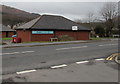
1
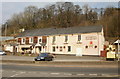
The Darran, Risca
Pub located at the west end of St Mary Street, on the corner of Darran Road.
The pink part of the building was the original pub, built in 1882. The pub entrance is now in the newer extension on the left.
Image: © Jaggery
Taken: 11 Mar 2010
0.03 miles
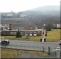
2
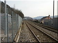
Railway lines heading southeast from Lime Kiln level crossing, Risca
The next station is this direction, on the Ebbw Vale Parkway to Cardiff Central route, is Risca & Pontymister, nearly 2 kilometres distant.
Viewed from Lime Kiln level crossing. http://www.geograph.org.uk/photo/1759011
The view in the opposite direction. http://www.geograph.org.uk/photo/1759071
Image: © Jaggery
Taken: 11 Mar 2010
0.03 miles
3
Ravenswood Court, Risca
Viewed across St Mary Street looking towards Risca Surgery. Lloyds Pharmacy is on the left.
Image: © Jaggery
Taken: 10 Jan 2017
0.04 miles
4
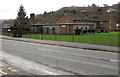
Derelict former Ty Darran care home, Risca
Viewed in January 2017. Metal sheeting cover windows and doors of the former care home which closed in 2010.
Image: © Jaggery
Taken: 10 Jan 2017
0.05 miles
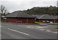
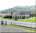
5
Ty Darran, Risca
Residential care home located on the south side of Cromwell Road.
Update May 2011: Ty Darran was closed http://www.geograph.org.uk/photo/2419733 in 2010.
Image: © Jaggery
Taken: 11 Mar 2010
0.06 miles
6
Former Ty Darran care home, Risca
Metal plates cover windows and doors of the former Ty Darran care home which closed in 2010. The closure which caused 11 elderly residents to be rehoused, occurred despite petitions and protests from the local community. The council said the decision would help address surplus beds in the area, help care for more elderly people in their own home and save £400,000 that would have been needed to refurbish Ty Darran.
http://www.geograph.org.uk/photo/1759148 to a view taken a few months before closure. Ty Darran is on the corner of St Mary Street and Ravenswood Court.
Image: © Jaggery
Taken: 10 Apr 2011
0.06 miles
7
Lloyds Pharmacy, Risca
The St Mary Street side of the pharmacy near Risca Surgery in Ravenswood Court.
Image: © Jaggery
Taken: 10 Jan 2017
0.06 miles
8
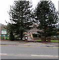
Tree-lined entrance to the former Ty Darran care home, Risca
From St Mary Street. Although the care home closed in 2010, the sign showing Ty Darran Residential Home for Older People is still in place on the left side of the entrance in January 2017.
Image: © Jaggery
Taken: 10 Jan 2017
0.06 miles
9
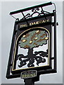
The Darran name sign, Risca
On a post outside this http://www.geograph.org.uk/photo/5249596 pub. The stylised depiction of an oak led me to the obvious conclusion that darran is Welsh for oak. I was wrong. The Welsh for oak is derwen. Perhaps darran is a local variant of derwen...
Image: © Jaggery
Taken: 10 Jan 2017
0.07 miles
10
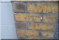
Ordnance Survey Cut Mark
This OS cut mark can be found on the wall of No4 St Mary Street. It marks a point 53.093m above mean sea level.
Image: © Adrian Dust
Taken: 11 May 2019
0.08 miles