IMAGES TAKEN NEAR TO
Penrhiw Road, NEWPORT, NP11 6GA
Introduction
This page details the photographs taken nearby to Penrhiw Road, NP11 6GA by members of the Geograph project.
The Geograph project started in 2005 with the aim of publishing, organising and preserving representative images for every square kilometre of Great Britain, Ireland and the Isle of Man.

There are currently over 7.5m images from over14,400 individuals and you can help contribute to the project by visiting https://www.geograph.org.uk
Image Map
Images are licensed for reuse under creativecommons.org/licenses/by-sa/2.0
Notes
- Clicking on the map will re-center to the selected point.
- The higher the marker number, the further away the image location is from the centre of the postcode.
Image Listing (75 Images Found)
Images are licensed for reuse under creativecommons.org/licenses/by-sa/2.0
Image
Details
Distance
1
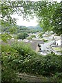
Monmouthshire & Brecon Canal (Crumlin Arm) near Risca
Image: © Gareth James
Taken: 25 Aug 2013
0.07 miles
2
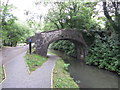
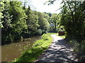
Towards Pen-y-Rhiw Bridge, Monmouthshire & Brecon Canal
Looking north on the former towpath (cycle lane) of the canal's disused Crumlin Arm to the grade II listed bridge.
Image: © M J Roscoe
Taken: 20 Oct 2017
0.07 miles
3
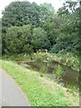
Vegetation in Monmouthshire and Brecon Canal
Image: © David Smith
Taken: 25 Sep 2021
0.08 miles
4
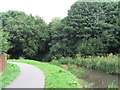
Monmouthshire & Brecon Canal (Crumlin Arm) near Risca
Image: © Gareth James
Taken: 25 Aug 2013
0.09 miles
7
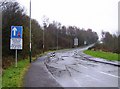
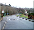
Traffic calming at Penrhiw
There are many estate roads running parallel to main roads in the valleys. Most have traffic calming to prevent significant rat-running, such as here between Fernlea and Penrhiw.
Image: © Graham Horn
Taken: 28 Dec 2007
0.14 miles
8
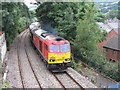
The Taffy Tug near Risca
Pathfinder Tours operated a railtour from Bristol to South Wales covering five branch lines (Ebbw Vale, Machen Quarry, Penarth, Cwmbargoed and Coryton), on which either passenger trains or locomotive-hauled trains are not normally seen. The tour was operated with two freight locomotives (Numbers 60063 and 60017) in top-and-tail formation.
Here the train passes near Risca while heading towards Ebbw Vale.
Image: © Gareth James
Taken: 25 Aug 2013
0.16 miles
9
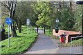
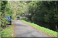
Canalside path west of Gelli Avenue, Risca
Foot and cycle lane alongside the disused Crumlin Arm of the Monmouthshire & Brecon Canal.
Image: © M J Roscoe
Taken: 20 Oct 2017
0.17 miles
10
SE edge of Fernlea, Risca
Behind the camera are houses http://www.geograph.org.uk/photo/2252145 on Fernlea. Ahead is a short stretch of wooded terrain on the approach to Holly Road, Penrhiw.
Image: © Jaggery
Taken: 17 Jan 2011
0.17 miles