IMAGES TAKEN NEAR TO
Fernlea, NEWPORT, NP11 6FX
Introduction
This page details the photographs taken nearby to Fernlea, NP11 6FX by members of the Geograph project.
The Geograph project started in 2005 with the aim of publishing, organising and preserving representative images for every square kilometre of Great Britain, Ireland and the Isle of Man.

There are currently over 7.5m images from over14,400 individuals and you can help contribute to the project by visiting https://www.geograph.org.uk
Image Map
Images are licensed for reuse under creativecommons.org/licenses/by-sa/2.0
Notes
- Clicking on the map will re-center to the selected point.
- The higher the marker number, the further away the image location is from the centre of the postcode.
Image Listing (52 Images Found)
Images are licensed for reuse under creativecommons.org/licenses/by-sa/2.0
Image
Details
Distance
1
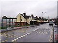
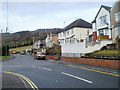
Houses at Fernlea
Some of the very few houses in this square. This road cuts the south-west corner of the square. Typically it runs parallel to the valley and is the highest road in the suburb of Fernlea.
Image: © Graham Horn
Taken: 28 Dec 2007
0.02 miles
2
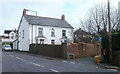
Cwm-y-nant farmhouse, Risca
The path to the farmhouse is from Fernlea, a residential road.
Image: © Jaggery
Taken: 17 Jan 2011
0.02 miles
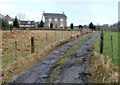
4
SE edge of Fernlea, Risca
Behind the camera are houses http://www.geograph.org.uk/photo/2252145 on Fernlea. Ahead is a short stretch of wooded terrain on the approach to Holly Road, Penrhiw.
Image: © Jaggery
Taken: 17 Jan 2011
0.07 miles
5
NW arm of Fernlea, Risca
The main course of Fernlea bends to the left. Ahead are houses on the NW arm of Fernlea and at the far end, wooded countryside.
Image: © Jaggery
Taken: 17 Jan 2011
0.08 miles
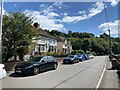
6
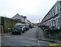
Highfield House, Risca
Located on the corner of Taylor Street and Fernlea. A stone inscription on a perimeter wall shows Highfield House 1886.
Image: © Jaggery
Taken: 17 Jan 2011
0.09 miles
7
Sansom Street, Risca
The view SE from the corner of Fernlea.
Image: © Jaggery
Taken: 17 Jan 2011
0.09 miles
8
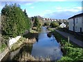
Monmouthshire and Brecon canal
Looking south east, from Darran Road
Image: © Roger Cornfoot
Taken: 1 Mar 2007
0.10 miles
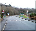
9
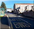
Bus stop and shelter on a steep hill in Risca
Looking up Navigation Road. Safle Bws is Welsh for bus stop.
Image: © Jaggery
Taken: 11 Jan 2014
0.10 miles
10
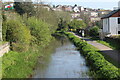
Canal south east of Navigation Road
Disused section of Crumlin Arm, the tow path is part of NCR 47.
Image: © M J Roscoe
Taken: 29 Apr 2023
0.12 miles