1
Crumlin Arm canal sign, Risca
The sign on the Temperance Road http://www.geograph.org.uk/photo/2238594 side of Navigation Road records in Welsh and English the history of this part of the former Monmouthshire and Brecon canal. The English text states:
The Crumlin Arm runs for 16 km from Cwmcarn to Newport. Opened in 1796 from Crumlin, it was worked until the 1940s. Today's journeys are made for leisure. Enjoy your visit.
Image: © Jaggery
Taken: 17 Jan 2011
0.03 miles
2
Fernlea, Risca
The central shopping areas of Risca and Pontymister are built on mainly flat ground in the valley of the Ebbw River. Many of the residential areas are built on steep ground to the north, such as here on Fernlea, which climbs steeply to the NE away from the former Monmouthshire and Brecon canal. http://www.geograph.org.uk/photo/2238592
Image: © Jaggery
Taken: 17 Jan 2011
0.03 miles
3
Public footpath, Fernlea, Risca
The footpath runs from Fernlea between allotments and houses.
Image: © Jaggery
Taken: 17 Jan 2011
0.03 miles
4
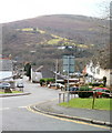
The view from the top of Fernlea, Risca
Fernlea, a street near the northern edge of Risca, descends towards Navigation Road and Church Road. The tower http://www.geograph.org.uk/photo/1007937 on high ground in the distance is at the top of Mynydd Machen, 362 metres (1188 feet) above sea level.
Image: © Jaggery
Taken: 17 Jan 2011
0.03 miles
5
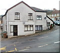
Navigation House, Risca
Located at the top end of Navigation Road, the building is now divided into 5 flats. It was probably formerly used as canal offices for the nearby Crumlin arm http://www.geograph.org.uk/photo/2238595 of the former Monmouthshire & Brecon canal.
Image: © Jaggery
Taken: 17 Jan 2011
0.03 miles
6
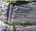
Ordnance Survey Cut Mark
This OS cut mark can be found on the Railway Bridge, Church Road. It marks a point 53.919m above mean sea level.
Image: © Adrian Dust
Taken: 11 May 2019
0.04 miles
7
Canalside houses, Temperance Hill, Risca
The view west from Navigation Road. The houses are alongside the Crumlin Arm http://www.geograph.org.uk/photo/2238595 of the former Monmouthshire and Brecon canal.
Image: © Jaggery
Taken: 17 Jan 2011
0.04 miles
8
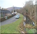
Road west from Navigation Road, Risca
An apparently unnamed road heads away from Navigation Road towards Darran Road.
It runs parallel with the former Monmouthshire and Brecon canal.
Image: © Jaggery
Taken: 17 Jan 2011
0.04 miles
9
Fernlea allotments, Risca
A small area of allotments on relatively flat ground located on the west side of steeply-rising Navigation Road and Fernlea. The allotments are owned by Caerphilly County Borough Council. A plot, for growing vegetables, fruit or flowers, can be rented for a small annual payment.
Image: © Jaggery
Taken: 17 Jan 2011
0.04 miles
10
Risca : short cut from Navigation Road to Church Road
Steps and a steeply descending path give a short cut from Navigation Road to Church Road, near American Villas. http://www.geograph.org.uk/photo/2238577
Image: © Jaggery
Taken: 17 Jan 2011
0.04 miles


