IMAGES TAKEN NEAR TO
Railway Street, NEWPORT, NP11 6FA
Introduction
This page details the photographs taken nearby to Railway Street, NP11 6FA by members of the Geograph project.
The Geograph project started in 2005 with the aim of publishing, organising and preserving representative images for every square kilometre of Great Britain, Ireland and the Isle of Man.

There are currently over 7.5m images from over14,400 individuals and you can help contribute to the project by visiting https://www.geograph.org.uk
Image Map
Images are licensed for reuse under creativecommons.org/licenses/by-sa/2.0
Notes
- Clicking on the map will re-center to the selected point.
- The higher the marker number, the further away the image location is from the centre of the postcode.
Image Listing (162 Images Found)
Images are licensed for reuse under creativecommons.org/licenses/by-sa/2.0
Image
Details
Distance
1

Navigation Road, Risca
Navigation Road climbs away from Church Road towards the former Monmouthshire and Brecon canal.
Image: © Jaggery
Taken: 17 Jan 2011
0.02 miles
2
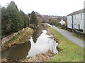
Former Monmouthshire and Brecon canal viewed from Navigation Road Risca
The view SE from Navigation Road.
Image: © Jaggery
Taken: 17 Jan 2011
0.02 miles
3

Rifleman Street, Risca
Dead end street on the northeast side of St Mary Street.
Image: © Jaggery
Taken: 10 Jan 2017
0.02 miles
4
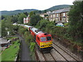
The Taffy Tug near Risca
Pathfinder Tours operated a railtour - The Taffy Tug - from Bristol to South Wales covering five branch lines (Ebbw Vale, Machen Quarry, Penarth, Cwmbargoed and Coryton), on which either passenger trains or locomotive-hauled trains are not normally seen. The tour was operated with two freight locomotives (Class 60s, nicknamed Tugs, Nos. 60063 and 60017) in top-and-tail formation.
Here the train passes near Risca while heading towards Ebbw Vale.
Image: © Gareth James
Taken: 25 Aug 2013
0.03 miles
5
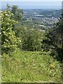
Risca viewed from Medart
View from the Cwm Carn Forest Drive.
Image: © Alan Hughes
Taken: 14 Jun 2022
0.04 miles
6
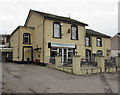
Risca Workmans Top Club & Institute
The spelling and punctuation of the club's name is as it appears above the entrance here at 60 St Mary Street.
Image: © Jaggery
Taken: 10 Jan 2017
0.04 miles
7
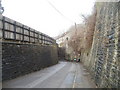
Eastern approach to Church Road railway bridge, Risca
The view west along Church Road towards a blind bend under a railway bridge http://www.geograph.org.uk/photo/2238570 carrying the Ebbw Valley Railway. The steps http://www.geograph.org.uk/photo/2238572 lead up to Sarn Place.
Image: © Jaggery
Taken: 17 Jan 2011
0.05 miles
8
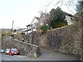
American Villas, Church Road, Risca
Houses set back from, and above, the NE side of Church Road.
Image: © Jaggery
Taken: 17 Jan 2011
0.05 miles
9
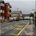
Top Club bus stop and shelter, Risca
Alongside the B4591 St Mary Street, outside Risca Workmans Top Club & Institute. http://www.geograph.org.uk/photo/5250362
This stop is for buses to Newport, and for the X16 bus to Cardiff.
Image: © Jaggery
Taken: 10 Jan 2017
0.05 miles
10
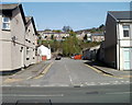
Rifleman Street, Risca
Viewed from St Mary Street. Rifleman Street is a 100-metre long cul-de-sac. Its far end is at the edge of the Ebbw Valley Railway line.
Image: © Jaggery
Taken: 10 Apr 2011
0.06 miles