IMAGES TAKEN NEAR TO
Tir-y-Cwm Lane, NEWPORT, NP11 6ER
Introduction
This page details the photographs taken nearby to Tir-y-Cwm Lane, NP11 6ER by members of the Geograph project.
The Geograph project started in 2005 with the aim of publishing, organising and preserving representative images for every square kilometre of Great Britain, Ireland and the Isle of Man.

There are currently over 7.5m images from over14,400 individuals and you can help contribute to the project by visiting https://www.geograph.org.uk
Image Map
Images are licensed for reuse under creativecommons.org/licenses/by-sa/2.0
Notes
- Clicking on the map will re-center to the selected point.
- The higher the marker number, the further away the image location is from the centre of the postcode.
Image Listing (132 Images Found)
Images are licensed for reuse under creativecommons.org/licenses/by-sa/2.0
Image
Details
Distance
1
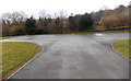
Car park at the southern end of Danygraig Cemetery, Risca
The car park is on land recently acquired to extend the cemetery at its southern edge.
There is another car park http://www.geograph.org.uk/photo/3408977 at the cemetery entrance.
Image: © Jaggery
Taken: 11 Apr 2013
0.01 miles
2
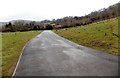
Southern end of Danygraig Cemetery, Risca
The southern end of the cemetery used to be about where the camera is. Recently-acquired land has extended the cemetery southwards. There is a new car park http://www.geograph.org.uk/photo/3408986 at the far end.
Image: © Jaggery
Taken: 11 Apr 2013
0.02 miles
3
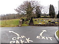
Road junction in Danygraig Cemetery, Risca
Turn left for the recently-extended southern part of the cemetery and a new car park http://www.geograph.org.uk/photo/3408986 or right for the exit into Tir-y-Cwm Road.
Image: © Jaggery
Taken: 11 Apr 2013
0.07 miles
4
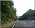
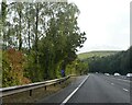
A467 passing Pontymister
On the right, the wall marks the edge of a cemetery
Image: © David Smith
Taken: 27 Sep 2021
0.09 miles
5
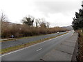
A467 between Risca and Pontymister
Viewed from Danygraig Cemetery.The A467 heads SE towards Pontymister.
The vegetation on the left lines the bank of the River Ebbw.
Image: © Jaggery
Taken: 11 Apr 2013
0.09 miles
7
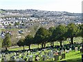
Dan-y-graig cemetery, Risca
Looking across the valley towards the Ty-Sign estate http://www.geograph.org.uk/photo/4845721 .
Image: © Robin Drayton
Taken: 24 Feb 2016
0.12 miles
8
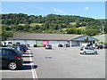
Scenic Lidl, Risca
The visitor entering the large car park from Commercial Street is greeted by a view of the wooded hills behind Lidl's Risca supermarket.
Image: © Jaggery
Taken: 16 Aug 2010
0.12 miles
9
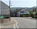
Pontymister boundary
A view SE along the B4591 which is named Tredegar Street, Risca on the camera side, and Commercial Street, Pontymister beyond the boundary sign, on the corner of Station Road.
Image: © Jaggery
Taken: 10 Apr 2011
0.12 miles
10
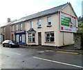
Risca Dental Practice, Pontymister
Located at 3 Commercial Street, a few metres on the Pontymister side of the boundary with Risca.
Image: © Jaggery
Taken: 30 Nov 2011
0.12 miles