IMAGES TAKEN NEAR TO
Mill Street, NEWPORT, NP11 6EF
Introduction
This page details the photographs taken nearby to Mill Street, NP11 6EF by members of the Geograph project.
The Geograph project started in 2005 with the aim of publishing, organising and preserving representative images for every square kilometre of Great Britain, Ireland and the Isle of Man.

There are currently over 7.5m images from over14,400 individuals and you can help contribute to the project by visiting https://www.geograph.org.uk
Image Map
Images are licensed for reuse under creativecommons.org/licenses/by-sa/2.0
Notes
- Clicking on the map will re-center to the selected point.
- The higher the marker number, the further away the image location is from the centre of the postcode.
Image Listing (172 Images Found)
Images are licensed for reuse under creativecommons.org/licenses/by-sa/2.0
Image
Details
Distance
1
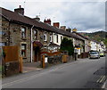
West side of Mill Street, Pontymister
The house on the left is at the edge of a fenced-off area north of Mill Street Car Park. https://www.geograph.org.uk/photo/5759479
Image: © Jaggery
Taken: 1 May 2018
0.01 miles
2
Warning sign - School/Ysgol, Mill Street, Pontymister
The English/Welsh sign is on the approach to Ty Isaf Infants & Nursery School.
Image: © Jaggery
Taken: 1 May 2018
0.02 miles
3
Two bridges, Mill Street, Risca
Viewed from the north, from Mill Terrace. There is a sharp bend in the road just before the bridges. There is a very narrow pavement on the right side of the roadway on the left, but the sensible pedestrian option is to use the path under the bridge on the right.
The bridges carry the Cardiff - Ebbw Vale railway line. Risca and Pontymister Station is a few tens of metres away. The road bridge has headroom of 11 feet (3.3 metres)
Image: © Jaggery
Taken: 11 Mar 2010
0.03 miles
4
Mill Terrace, Risca
Looking towards Mill Street. Beyond the left edge of the photo are the Cardiff to Ebbw Vale railway lines, on their approach to Risca and Pontymister station.
Image: © Jaggery
Taken: 11 Mar 2010
0.03 miles
5
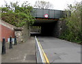
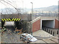
Mill Street railway bridge, Pontymister
The bridge carries railway lines over Mill Street about 100 metres east of Risca & Pontymister railway station.
Headroom shown on the bridge is 3.35 metres/11' 0".
Image: © Jaggery
Taken: 1 May 2018
0.06 miles
6
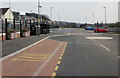
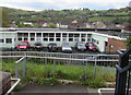
Spacious parking area, Risca and Pontymister railway station
Risca and Pontymister station was built during 2007, with the park and ride motorist very much in mind. Parking, viewed here from the west, is available alongside the station. There are 88 spaces plus 6 for disabled badge holders.
Image: © Jaggery
Taken: 11 Mar 2010
0.06 miles
7
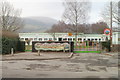
Ty Isaf Infants School, Risca
Viewed across Mill Street. A colourful mural and colourful entrance gates (red, blue, yellow and green) greet the visitor. The infants' school also has a nursery, giving an age range of 3 to 11 for the c180 children enrolled here.
Image: © Jaggery
Taken: 17 Feb 2011
0.06 miles
8
North side of Ty Isaf Infants & Nursery School, Pontymister
Viewed from this path. https://www.geograph.org.uk/photo/5759517
Image: © Jaggery
Taken: 1 May 2018
0.06 miles
9
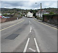
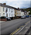
North along Mill Street, Pontymister
Ahead for an entrance to Risca & Pontymister railway station. The Springfield Road junction is on the right.
Image: © Jaggery
Taken: 1 May 2018
0.06 miles
10
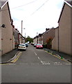
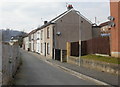
Isaf Road, Pontymister
Dead-end road on the east side of Mill Street.
Image: © Jaggery
Taken: 1 May 2018
0.07 miles