IMAGES TAKEN NEAR TO
Danygraig Road, NEWPORT, NP11 6DB
Introduction
This page details the photographs taken nearby to Danygraig Road, NP11 6DB by members of the Geograph project.
The Geograph project started in 2005 with the aim of publishing, organising and preserving representative images for every square kilometre of Great Britain, Ireland and the Isle of Man.

There are currently over 7.5m images from over14,400 individuals and you can help contribute to the project by visiting https://www.geograph.org.uk
Image Map
Images are licensed for reuse under creativecommons.org/licenses/by-sa/2.0
Notes
- Clicking on the map will re-center to the selected point.
- The higher the marker number, the further away the image location is from the centre of the postcode.
Image Listing (267 Images Found)
Images are licensed for reuse under creativecommons.org/licenses/by-sa/2.0
Image
Details
Distance
1
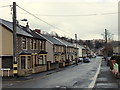
Danygraig Road, Risca
A view east from the corner of Ebbw Street.
Image: © Jaggery
Taken: 11 Apr 2013
0.01 miles
2
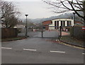
Exit from Risca Primary School into Danygraig Road, Risca
Various notices and signs show that this is not an entrance to, but an exit from, the school.
The main entrance is from Graig View.
Image: © Jaggery
Taken: 20 Dec 2016
0.02 miles
3

North along Gwendoline Road, Risca
Towards Danygraig Road from concrete posts at the southern end of Gwendoline Road.
Image: © Jaggery
Taken: 20 Dec 2016
0.02 miles
4

End of the 20 zone, Gwendoline Road, Risca
The 20mph speed limit past Risca Primary School increases to 30mph at the Danygraig Road junction.
Image: © Jaggery
Taken: 20 Dec 2016
0.02 miles
5
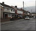
West side of Gwendoline Road, Risca
The houses are opposite Risca Primary School.
Image: © Jaggery
Taken: 20 Dec 2016
0.02 miles
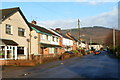
6
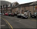
Change of house type, Danygraig Road, Risca
Houses on the north side of the road.
Image: © Jaggery
Taken: 20 Dec 2016
0.02 miles
7

Gwendoline Road speed bump, Risca
The speed bump is in a 20mph maximum speed zone past Risca Primary School.
Image: © Jaggery
Taken: 20 Dec 2016
0.03 miles
8
Gwendoline Road, Risca
Looking north along Gwendoline Road from the edge of a rugby club's car park on the east bank of the River Ebbw.
Image: © Jaggery
Taken: 30 Nov 2011
0.04 miles
9
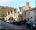
Danygraig Road houses, Risca
Houses on the north side of the road, near the Graig View junction.
Image: © Jaggery
Taken: 30 Nov 2011
0.04 miles
10
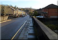
Risca : Looking east along Danygraig Road from the river bridge
Viewed along the bridge over the River Ebbw looking in the direction of Tredegar Street.
Image: © Jaggery
Taken: 30 Nov 2011
0.04 miles