IMAGES TAKEN NEAR TO
Chapel-Of-Ease, Abercarn, NEWPORT, NP11 5LH
Introduction
This page details the photographs taken nearby to NP11 5LH by members of the Geograph project.
The Geograph project started in 2005 with the aim of publishing, organising and preserving representative images for every square kilometre of Great Britain, Ireland and the Isle of Man.

There are currently over 7.5m images from over14,400 individuals and you can help contribute to the project by visiting https://www.geograph.org.uk
Image Map
Images are licensed for reuse under creativecommons.org/licenses/by-sa/2.0
Notes
- Clicking on the map will re-center to the selected point.
- The higher the marker number, the further away the image location is from the centre of the postcode.
Image Listing (47 Images Found)
Images are licensed for reuse under creativecommons.org/licenses/by-sa/2.0
Image
Details
Distance
1
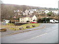
Corner of Brook Street and High Meadow, Abercarn
Viewed from near the B4591. The house behind the red car is 1, Brook Street.
Image: © Jaggery
Taken: 23 Jan 2011
0.02 miles
2
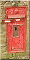
Closeup view of a disused George V postbox, Abercarn
The disused postbox is in a wall http://www.geograph.org.uk/photo/2286842 between Hill Street and the B4591. Originally showing OUT OF SERVICE, the metal strip covering the mouth of the box is itself nearly out of service, presumably after some attention from vandals. It may not be long before the ivy partly covering the wall grows over this sorry specimen.
Image: © Jaggery
Taken: 24 Jan 2011
0.02 miles
3
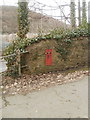
Out-of-service George V postbox, Abercarn
A battered postbox in a wall between Hill Street and the B4591 has been replaced by a postbox mounted on a stand nearby. The metal strip across the mouth of box is itself in a battered condition. http://www.geograph.org.uk/photo/2286864
Image: © Jaggery
Taken: 24 Jan 2011
0.02 miles
4
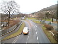
A467 and B4591, Abercarn
Viewed from a footbridge. http://www.geograph.org.uk/photo/2295819 The A467 on the left runs alongside the B4591.
Image: © Jaggery
Taken: 23 Jan 2011
0.05 miles
5
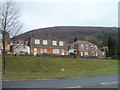
High Meadows, Abercarn
High Meadows, on the east side of the A467, contains about 100 houses. Those seen here, viewed across the A467, are low-numbered houses. Highest-numbered are furthest from the A467, out of shot.
Image: © Jaggery
Taken: 23 Jan 2011
0.07 miles
6
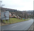
A467 reaches Abercarn from the NW
The view SE along the A467 past the white-on-green Abercarn boundary sign towards the roundabout at the B4591 junction.
Image: © Jaggery
Taken: 23 Jan 2011
0.07 miles
7
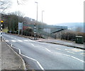
A467 footbridge, Abercarn
Viewed across the B4591. The A467 runs (at a slightly lower level) parallel with the B4591 for much of their course through Abercarn.
Image: © Jaggery
Taken: 23 Jan 2011
0.07 miles
8
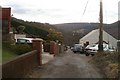
Chapel Street, Abercarn
The view to the south along Chapel Street, a cul-de-sac connecting with Hill Street (ahead).
Image: © Jaggery
Taken: 24 Jan 2011
0.08 miles
9
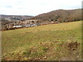
Field bordering Chapel Street, Abercarn
Viewed from a path http://www.geograph.org.uk/photo/2286549
The field is between Abercarn cemetery http://www.geograph.org.uk/photo/2286446 and Chapel Street.
Image: © Jaggery
Taken: 24 Jan 2011
0.08 miles
10
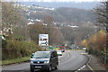
Northern approach on A467 to Abercarn
Approach to roundabout at junctions of B4591 and road to new housing estate on the A467 on the northern boundary of Abercarn.
Image: © M J Roscoe
Taken: 22 Nov 2018
0.08 miles