IMAGES TAKEN NEAR TO
Farm Road, NEWPORT, NP11 5HX
Introduction
This page details the photographs taken nearby to Farm Road, NP11 5HX by members of the Geograph project.
The Geograph project started in 2005 with the aim of publishing, organising and preserving representative images for every square kilometre of Great Britain, Ireland and the Isle of Man.

There are currently over 7.5m images from over14,400 individuals and you can help contribute to the project by visiting https://www.geograph.org.uk
Image Map
Images are licensed for reuse under creativecommons.org/licenses/by-sa/2.0
Notes
- Clicking on the map will re-center to the selected point.
- The higher the marker number, the further away the image location is from the centre of the postcode.
Image Listing (28 Images Found)
Images are licensed for reuse under creativecommons.org/licenses/by-sa/2.0
Image
Details
Distance
1
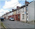
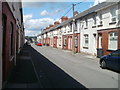
Change of housing type, Rectory Road, Sofrydd
Behind the camera, the houses on Rectory Road are detached or semi-detached. Ahead are long rows of terrace housing.
Image: © Jaggery
Taken: 29 Jun 2011
0.04 miles
2
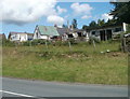
Swffryd Farm, Sofrydd
This is the southern edge of the farm, viewed from Sofrydd Road (B4471). The farm is next door to a car sales business. http://www.geograph.org.uk/photo/2482821 The northern side of the farm borders, appropriately, Farm Road.
Image: © Jaggery
Taken: 29 Jun 2011
0.06 miles
3
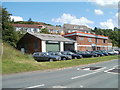
Jaguars galore, Sterling Cars, Sofrydd
A line of various models of Jaguar car are outside the Sofrydd Road (B4471) premises of Sterling Cars. The larger building with boarded-up windows on the right is a derelict former fish bar. http://www.geograph.org.uk/photo/2482812
Image: © Jaggery
Taken: 29 Jun 2011
0.06 miles
4
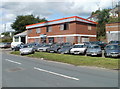
Derelict former fish bar, Sofrydd
The boarded-up building is the former Swffryd Fish Bar on Sofrydd Road (B4471). A local told me that the business closed nearly a decade ago and that a van now serves the fish and chip needs of the village.
The Jaguar cars on display belong to Sterling Cars, whose premises are on the left. http://www.geograph.org.uk/photo/2482821
Image: © Jaggery
Taken: 29 Jun 2011
0.06 miles
5
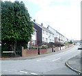
Middle section of Rectory Road, Sofrydd
This part of Rectory Road contains long rows of terrace housing on both sides of the street.
Image: © Jaggery
Taken: 29 Jun 2011
0.11 miles
6
Baillie Smith Avenue, Sofrydd
A view east from Walters Avenue.
Image: © Jaggery
Taken: 29 Jun 2011
0.11 miles
7

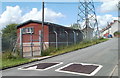
ACF hut dwarfed by pylon, Sofrydd
On the south side of Rectory Road, an electricity pylon towers over an Army Cadet Force hut. http://www.geograph.org.uk/photo/2482506
Image: © Jaggery
Taken: 29 Jun 2011
0.13 miles
8
ACF hut, Sofrydd
Located on the south side of Rectory Road, next to an electricity pylon. http://www.geograph.org.uk/photo/2482500
The hut is used by the Swffryd detachment of Gwent ACF (Army Cadet Force).
The spellings Swffryd and Sofrydd are used with about equal frequency in the village.
Image: © Jaggery
Taken: 29 Jun 2011
0.13 miles
9

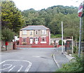
Bethesda Pentecostal Chapel, Sofrydd
This is the only place of worship in the village. Viewed across Rectory Road.
Image: © Jaggery
Taken: 29 Jun 2011
0.14 miles
10
Semis facing the Rectory Road turning, Sofrydd
Houses named Fernleigh and Rudgedale, on the north side of the B4471, viewed from the eastern edge of Rectory Road.
Image: © Jaggery
Taken: 29 Jun 2011
0.15 miles