IMAGES TAKEN NEAR TO
Rhyswg Road, NEWPORT, NP11 5HB

Introduction

This page details the photographs taken nearby to Rhyswg Road, NP11 5HB by members of the Geograph project.

The Geograph project started in 2005 with the aim of publishing, organising and preserving representative images for every square kilometre of Great Britain, Ireland and the Isle of Man.

There are currently over 7.5m images from over14,400 individuals and you can help contribute to the project by visiting https://www.geograph.org.uk

Image Map


Images are licensed for reuse under creativecommons.org/licenses/by-sa/2.0
Notes
  • Clicking on the map will re-center to the selected point.
  • The higher the marker number, the further away the image location is from the centre of the postcode.

Image Listing (90 Images Found)

Images are licensed for reuse under creativecommons.org/licenses/by-sa/2.0
  • ...
Image
Details
Distance
1
Ordnance Survey Cut Mark
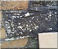
This OS cut mark can be found on No1 Rhyswg Road. It marks a point 110.292m above mean sea level.
Image: © Adrian Dust Taken: 11 May 2019
0.04 miles
2
Rhyswg Bar & Grill, Abercarn
Viewed across the B4591 Commercial Road.
Image: © Jaggery Taken: 20 Dec 2016
0.07 miles
3
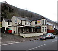
Rhyswg Road, Abercarn
Ascending from the B4591.
Image: © Jaggery Taken: 20 Dec 2016
0.08 miles
4
Abercarn in the snow
Image: © andy dolman Taken: 3 Feb 2009
0.09 miles
5
Junction of Rhyswg Road and the B4591, Abercarn
Rhyswg Road ascends from the B4591. The railings on the right separate the B4591 from the A467. The two roads are side by side in this area for about 500 metres.
Image: © Jaggery Taken: 20 Dec 2016
0.10 miles
6
Fast Parts, Abercarn
The east side of Fast Parts in the Prince of Wales Industrial Estate extends for 50 metres along the A467. Fast Parts sell car & commercial motor vehicle spares & accessories.
Image: © Jaggery Taken: 20 Dec 2016
0.10 miles
7
Ordnance Survey Cut Mark
This OS cut mark can be found on the wall east side of the road. It marks a point 93.254m above mean sea level.
Image: © Adrian Dust Taken: 11 May 2019
0.11 miles
8
B4591 diverges from the A467, Abercarn
Behind the camera, the B4591 and A467 are side by side http://www.geograph.org.uk/photo/5234677 for about 500 metres. Ahead, the B4591 (here named High Street Abercarn) diverges from the A467. Further ahead, the two roads are close together again. The northern end of the B4591 is about a kilometre ahead, at an A467 junction.
Image: © Jaggery Taken: 20 Dec 2016
0.11 miles
9
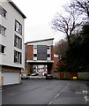
Cwrt Dyffryn, Abercarn
Modern flats set back from the east side of High Street.
Image: © Jaggery Taken: 14 Jan 2017
0.12 miles
10
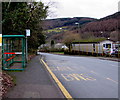
Library bus stop and shelter, Abercarn
Alongside the B4591 High Street, a few metres from Abercarn Library. http://www.geograph.org.uk/photo/5253537 In January 2017, the bus stop sign shows service 151 to Newport and X16 to Cardiff.
Image: © Jaggery Taken: 14 Jan 2017
0.13 miles
  • ...