1
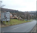
Northern approach on A467 to Abercarn
Approach to roundabout at junctions of B4591 and road to new housing estate on the A467 on the northern boundary of Abercarn.
Image: © M J Roscoe
Taken: 22 Nov 2018
0.03 miles
2
High Meadows, Abercarn
High Meadows, on the east side of the A467, contains about 100 houses. Those seen here, viewed across the A467, are low-numbered houses. Highest-numbered are furthest from the A467, out of shot.
Image: © Jaggery
Taken: 23 Jan 2011
0.03 miles
3
A467 reaches Abercarn from the NW
The view SE along the A467 past the white-on-green Abercarn boundary sign towards the roundabout at the B4591 junction.
Image: © Jaggery
Taken: 23 Jan 2011
0.03 miles
4
River Ebbw by Coed Celynen Drive
Looking upstream from bridge into housing estate.
Image: © M J Roscoe
Taken: 6 Jan 2019
0.04 miles
5
Riverside footpath, Coed Celynen Drive
Combined cycle and pedestrian path, between the housing estate and River Ebbw
Image, to Newbridge.
Image: © M J Roscoe
Taken: 6 Jan 2019
0.04 miles
6
Derelict section of canal, near Abercarn
Dry section of the Crumlin Arm of the Mon & Brec Canal below the A467. A puddle of water can just be seen at bottom right.
Image: © M J Roscoe
Taken: 22 Nov 2018
0.06 miles
7
Ebbw River weir, Abercarn
The houses are on Coed Celynen Drive.
Image: © Jaggery
Taken: 23 Jan 2011
0.07 miles
8
Cul-de-sac off Coed Celynen Drive
New houses on housing estate on site of former Celynen Collieries, viewed from a lay-by on the A467.
Image: © M J Roscoe
Taken: 22 Nov 2018
0.08 miles
9
A467 and B4591, Abercarn
Viewed from a footbridge. http://www.geograph.org.uk/photo/2295819 The A467 on the left runs alongside the B4591.
Image: © Jaggery
Taken: 23 Jan 2011
0.10 miles
10
Small footbridge across stream flowing into Ebbw River, Abercarn
A small footbridge on the east bank of the Ebbw River crosses a small stream, near the perimeter of Abercarn Primary School. http://www.geograph.org.uk/photo/2295064
Image: © Jaggery
Taken: 23 Jan 2011
0.11 miles


