IMAGES TAKEN NEAR TO
Graig Road, NEWPORT, NP11 5FS
Introduction
This page details the photographs taken nearby to Graig Road, NP11 5FS by members of the Geograph project.
The Geograph project started in 2005 with the aim of publishing, organising and preserving representative images for every square kilometre of Great Britain, Ireland and the Isle of Man.

There are currently over 7.5m images from over14,400 individuals and you can help contribute to the project by visiting https://www.geograph.org.uk
Image Map
Images are licensed for reuse under creativecommons.org/licenses/by-sa/2.0
Notes
- Clicking on the map will re-center to the selected point.
- The higher the marker number, the further away the image location is from the centre of the postcode.
Image Listing (51 Images Found)
Images are licensed for reuse under creativecommons.org/licenses/by-sa/2.0
Image
Details
Distance
1
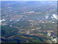
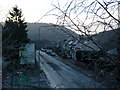
Newbridge from the air
Newbridge is in the foreground, with Blackwood and Pontllanfraith in the distance.
Viewed from a Bristol bound flight from Glasgow.
Image: © Thomas Nugent
Taken: 11 Oct 2010
0.09 miles
2
Celynen roundabout A472 / A467
Looking East from bridge at Penrhiwbica at Celynen viaduct and roundabout
Image: © Phil White
Taken: 11 Jul 2006
0.09 miles
3

Pantside Cottages, Newbridge
A row of four cottages set back from Pant Road, adjacent to Celynen roundabout.
Image: © Jaggery
Taken: 16 Aug 2010
0.10 miles
5
End of disused canal, Newbridge
Northernmost remaining section of the Crumlin Arm, Mon & Brec canal.
Image: © M J Roscoe
Taken: 13 Mar 2020
0.11 miles
6
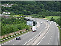
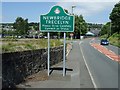
A467 entering Newbridge/Trecelyn
One might have expected the town sign to be further north, but no, here it is, behind the tree branches below the roundabout directional sign. Taken from a footbridge crossing the high speed road.
Image: © Graham Horn
Taken: 6 Jan 2008
0.12 miles
7
Please Drive Carefully, Newbridge/Trecelyn
Image: © Kev Griffin
Taken: 1 Jul 2008
0.12 miles
8
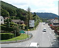
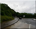
The view SE from a footbridge across the A467
At the left corner is the junction with Central Avenue, then the turning for Woodland Drive in front of a large white direction sign. Between the two turnings is a green sign marking the edge of Newbridge. Ahead, just out of view, the A467 meets the A472 at Celynen roundabout.
Image: © Jaggery
Taken: 16 Aug 2010
0.12 miles
9

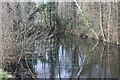
Disused canal, Newbridge
End of disused section of Crumlin Arm of Mon & Brec Canal next to sports field. It is now used by an angling club.
Image: © M J Roscoe
Taken: 13 Mar 2020
0.12 miles
10
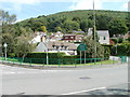
Newbridge : corner of Central Avenue and Woodland Drive
Viewed across Pant Road. With a scenic backdrop, Woodland Drive was well-named!
Image: © Jaggery
Taken: 16 Aug 2010
0.12 miles