IMAGES TAKEN NEAR TO
Hafodyrynys, Crumlin, NEWPORT, NP11 5BL
Introduction
This page details the photographs taken nearby to NP11 5BL by members of the Geograph project.
The Geograph project started in 2005 with the aim of publishing, organising and preserving representative images for every square kilometre of Great Britain, Ireland and the Isle of Man.

There are currently over 7.5m images from over14,400 individuals and you can help contribute to the project by visiting https://www.geograph.org.uk
Image Map
Images are licensed for reuse under creativecommons.org/licenses/by-sa/2.0
Notes
- Clicking on the map will re-center to the selected point.
- The higher the marker number, the further away the image location is from the centre of the postcode.
Image Listing (11 Images Found)
Images are licensed for reuse under creativecommons.org/licenses/by-sa/2.0
Image
Details
Distance
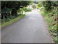
1
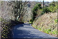
Cefn-crib Road, Hafodyrynys
Minor road coming uphill from Hafodyrynys before a bend to the right of the picture.
Image: © M J Roscoe
Taken: 26 Apr 2016
0.11 miles
2
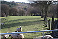
Sheep above Hafodyrynys
The western edge of the field in Image The sheep are now taking more notice of the photographer! In the middle background can be seen part of a plantation cleared of larch trees, a disease control measure.
Image: © M J Roscoe
Taken: 26 Apr 2016
0.16 miles
3
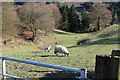
Sheep in valley, Hafodyrynys
Pasture above Graig Uchaf at the western end of Cwm y Glyn.
Image: © M J Roscoe
Taken: 26 Apr 2016
0.19 miles
4
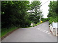
Junction Pont Bren Road and Cefn Crib Road
The road comes up from Hafodyrynys, and then goes on to some modern houses. The lane to the right leads up to Cefn Crib and the hill countryside.
Image: © Jessica Aidley
Taken: 6 Jul 2007
0.20 miles
5
Bont Pren boundary sign
Illustrating a subtlety of Welsh mutation beyond the understanding
of this contributor, Pontbren Road from Hafodyrynys passes the Bont Pren boundary sign. http://www.geograph.org.uk/photo/5529696
Image: © Jaggery
Taken: 8 Sep 2017
0.21 miles
6
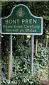
Bont Pren boundary sign detail
On the left here. http://www.geograph.org.uk/photo/5529692 The Please Drive Carefully request is also in Welsh.
Image: © Jaggery
Taken: 8 Sep 2017
0.21 miles
7
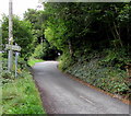
Cefn Crib Road ascends away from Hafodyrynys
A faded sign on the left points towards Cefn Crib.
In the distance, the 30mph speed limit increases to the National Speed Limit.
Image: © Jaggery
Taken: 8 Sep 2017
0.21 miles
9
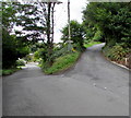
Junction at the northern edge of Hafodyrynys
The road to Cefn Crib ascends away from the road to Bont Pren.
The Bont Pren boundary sign http://www.geograph.org.uk/photo/5529696 is in the background on the left.
Image: © Jaggery
Taken: 8 Sep 2017
0.22 miles
10
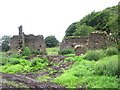
Ruined Farmhouse
This ruined farmhouse is opposite the entrance to Blaenyllwynau farm which keeps small black Welsh sheep with white markings on their faces.
Image: © Jessica Aidley
Taken: 6 Jul 2007
0.24 miles