IMAGES TAKEN NEAR TO
Llanover Street, NEWPORT, NP11 4SY
Introduction
This page details the photographs taken nearby to Llanover Street, NP11 4SY by members of the Geograph project.
The Geograph project started in 2005 with the aim of publishing, organising and preserving representative images for every square kilometre of Great Britain, Ireland and the Isle of Man.

There are currently over 7.5m images from over14,400 individuals and you can help contribute to the project by visiting https://www.geograph.org.uk
Image Map
Images are licensed for reuse under creativecommons.org/licenses/by-sa/2.0
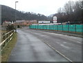
Notes
- Clicking on the map will re-center to the selected point.
- The higher the marker number, the further away the image location is from the centre of the postcode.
Image Listing (89 Images Found)
Images are licensed for reuse under creativecommons.org/licenses/by-sa/2.0
Image
Details
Distance
1
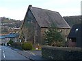
Cae'r Gorlan Baptist Church, West End, Abercarn
A large chapel building, situated on a hillside and still in use.
Image: © Robin Drayton
Taken: 14 Feb 2011
0.03 miles
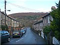
3
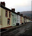
Colourful row of houses in West End, Abercarn
Railway Terrace houses in the West End area of Abercarn.
Image: © Jaggery
Taken: 20 Dec 2016
0.04 miles
4
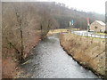
Abercarn : Ebbw River downstream from footbridge
Viewed from this http://www.geograph.org.uk/photo/2295032 footbridge.
The house is part of the Coed Celynen development, Phase 3, on the site of the former South Celynen colliery.
Image: © Jaggery
Taken: 23 Jan 2011
0.06 miles
5
Southern side of Coed Celynen housing development, Abercarn
The development, on the west bank of the Ebbw River, occupies the site of the former South Celynen colliery. The section ahead is known as 'Phase 3'.
Image: © Jaggery
Taken: 23 Jan 2011
0.06 miles
6
Abercarn : Ebbw River footbridge viewed from the NE
The view SW towards the bridge, http://www.geograph.org.uk/photo/2295032 which leads to a new housing development, Coed Celynen on the far side of the Ebbw River.
Image: © Jaggery
Taken: 23 Jan 2011
0.08 miles
7
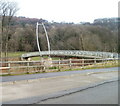
Ebbw River footbridge, Abercarn
The footbridge spans the Ebbw River, from the southern edge of new houses in Coed Celynen on this side, to the edge of Abercarn Primary School on the far side.
Image: © Jaggery
Taken: 23 Jan 2011
0.08 miles
8

Railway Terrace side of New Life Christian Church, Abercarn
This is the south side of New Life Christian Church. The north side is at 37 Llanover Street.
Image: © Jaggery
Taken: 20 Dec 2016
0.10 miles
9

Llanover Street bus stop, Abercarn
This side of the street for buses to Brynmawr (route X15) and Ebbw Vale (route X18).
Image: © Jaggery
Taken: 20 Dec 2016
0.10 miles
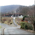
10

Benches and litter bin on a small green, Abercarn
On the corner of Islwyn Street and Llanover Street.
Image: © Jaggery
Taken: 20 Dec 2016
0.11 miles