IMAGES TAKEN NEAR TO
Islwyn Street, NEWPORT, NP11 4SR
Introduction
This page details the photographs taken nearby to Islwyn Street, NP11 4SR by members of the Geograph project.
The Geograph project started in 2005 with the aim of publishing, organising and preserving representative images for every square kilometre of Great Britain, Ireland and the Isle of Man.

There are currently over 7.5m images from over14,400 individuals and you can help contribute to the project by visiting https://www.geograph.org.uk
Image Map
Images are licensed for reuse under creativecommons.org/licenses/by-sa/2.0
Notes
- Clicking on the map will re-center to the selected point.
- The higher the marker number, the further away the image location is from the centre of the postcode.
Image Listing (69 Images Found)
Images are licensed for reuse under creativecommons.org/licenses/by-sa/2.0
Image
Details
Distance
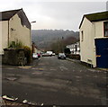
1

Benches and litter bin on a small green, Abercarn
On the corner of Islwyn Street and Llanover Street.
Image: © Jaggery
Taken: 20 Dec 2016
0.02 miles
2

Llanover Street bus stop, Abercarn
This side of the street for buses to Brynmawr (route X15) and Ebbw Vale (route X18).
Image: © Jaggery
Taken: 20 Dec 2016
0.02 miles
3
Junction of Railway Terrace and Islwyn Street, Abercarn
Towards Railway Terrace across Islwyn Street from the corner of Woodland Terrace.
Image: © Jaggery
Taken: 20 Dec 2016
0.03 miles
4
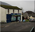
Lifestyle Express, West End, Abercarn
Islwyn Street convenience store on the corner of Railway Terrace in the West End area of Abercarn.
Image: © Jaggery
Taken: 20 Dec 2016
0.03 miles
5

Railway Terrace side of New Life Christian Church, Abercarn
This is the south side of New Life Christian Church. The north side is at 37 Llanover Street.
Image: © Jaggery
Taken: 20 Dec 2016
0.04 miles
6
Woodland Terrace, West End, Abercarn
On the west side of Islwyn Street in the West End area of Abercarn.
Image: © Jaggery
Taken: 20 Dec 2016
0.04 miles
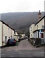
7

Islwyn Street, West End, Abercarn
Ascending northwards away from the corner of Llanover Street.
Image: © Jaggery
Taken: 20 Dec 2016
0.04 miles
8
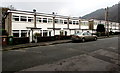
White houses, Railway Terrace, Abercarn
Old maps show that Abercarn railway station was located nearby. The station closed in 1962.
Image: © Jaggery
Taken: 20 Dec 2016
0.04 miles
9
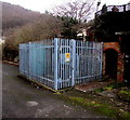
Crown Inn electricity substation, West End, Abercarn
The Western Power Distribution electricity substation is inside a fenced enclosure near the corner of Islwyn Street and Danyrhiw Terrace, on the north side of the Crown pub. http://www.geograph.org.uk/photo/5230356
The substation identifier is CROWN INN ABERCARN S/S 651219.
Image: © Jaggery
Taken: 20 Dec 2016
0.04 miles
10
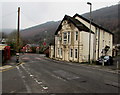
East side of the Crown, West End, Abercarn
Pub viewed across Bridge Street from the corner of Royal Close in the West End area of Abercarn.
Old maps show that Abercarn railway station was nearby. The station closed in 1962.
http://www.geograph.org.uk/photo/5230356 to another view of the pub.
Image: © Jaggery
Taken: 20 Dec 2016
0.05 miles