IMAGES TAKEN NEAR TO
Woodland Terrace, NEWPORT, NP11 4SQ
Introduction
This page details the photographs taken nearby to Woodland Terrace, NP11 4SQ by members of the Geograph project.
The Geograph project started in 2005 with the aim of publishing, organising and preserving representative images for every square kilometre of Great Britain, Ireland and the Isle of Man.

There are currently over 7.5m images from over14,400 individuals and you can help contribute to the project by visiting https://www.geograph.org.uk
Image Map
Images are licensed for reuse under creativecommons.org/licenses/by-sa/2.0
Notes
- Clicking on the map will re-center to the selected point.
- The higher the marker number, the further away the image location is from the centre of the postcode.
Image Listing (60 Images Found)
Images are licensed for reuse under creativecommons.org/licenses/by-sa/2.0
Image
Details
Distance
1
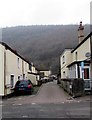
Woodland Terrace, West End, Abercarn
On the west side of Islwyn Street in the West End area of Abercarn.
Image: © Jaggery
Taken: 20 Dec 2016
0.03 miles
2
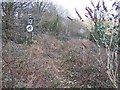
Overgrown railway trackbed approaching the site of Pantyresk level crossing at West End in Ebbw Vale
A private plateway built by Benjamin Hall* was opened about 1811 from the Monmouthshire Canal at Risca up to Manmoel Colliery (in the Upper Sirhowy Valley). The Great Western Railway leased it in 1877 and converted the section in the Sirhowy Valley to standard gauge. The Ebbw Vale section was also converted to standard gauge but not until 1912. Most of the line survived until 1991 to serve Oakdale Colliery, by which time it was one of the oldest lines to remain in use.
*Hall's son, also named Benjamin, designed the clock tower at the Houses of Parliament and gave his name to the bell, 'Big Ben.'
Image: © Ralph Rawlinson
Taken: 18 Feb 2006
0.04 miles
3
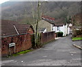
Ebbw Terrace, Abercarn
Houses on the north bank of the Ebbw River.
Image: © Jaggery
Taken: 20 Dec 2016
0.04 miles
4
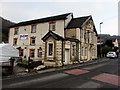
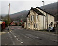
The Crown, West End, Abercarn
The Bridge Street side of the Danyrhiw Terrace pub in the West End area of Abercarn.
Old maps show that Abercarn railway station was located nearby. The station closed in 1962.
Image: © Jaggery
Taken: 20 Dec 2016
0.05 miles
5
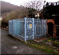
Crown Inn electricity substation, West End, Abercarn
The Western Power Distribution electricity substation is inside a fenced enclosure near the corner of Islwyn Street and Danyrhiw Terrace, on the north side of the Crown pub. http://www.geograph.org.uk/photo/5230356
The substation identifier is CROWN INN ABERCARN S/S 651219.
Image: © Jaggery
Taken: 20 Dec 2016
0.06 miles
6
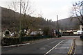
East side of the Crown, West End, Abercarn
Pub viewed across Bridge Street from the corner of Royal Close in the West End area of Abercarn.
Old maps show that Abercarn railway station was nearby. The station closed in 1962.
http://www.geograph.org.uk/photo/5230356 to another view of the pub.
Image: © Jaggery
Taken: 20 Dec 2016
0.06 miles
7

Ebbw River, Abercarn
Downstream along the Ebbw (Afon Ebwy in Welsh) from Bridge Street Abercarn.
The Ebbw is a major tributary of the River Usk.
Image: © Jaggery
Taken: 20 Dec 2016
0.06 miles
8
Road bridge over the Ebbw River, Abercarn
The bridge carries Bridge Street over the river.
Image: © Jaggery
Taken: 20 Dec 2016
0.06 miles
9
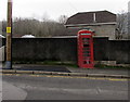
Red phonebox, Bridge Street, West End, Abercarn
Located here, http://www.geograph.org.uk/photo/5230427 opposite the Crown.
Image: © Jaggery
Taken: 20 Dec 2016
0.06 miles
10
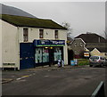
Lifestyle Express, West End, Abercarn
Islwyn Street convenience store on the corner of Railway Terrace in the West End area of Abercarn.
Image: © Jaggery
Taken: 20 Dec 2016
0.07 miles