IMAGES TAKEN NEAR TO
Canal Terrace, NEWPORT, NP11 4SF
Introduction
This page details the photographs taken nearby to Canal Terrace, NP11 4SF by members of the Geograph project.
The Geograph project started in 2005 with the aim of publishing, organising and preserving representative images for every square kilometre of Great Britain, Ireland and the Isle of Man.

There are currently over 7.5m images from over14,400 individuals and you can help contribute to the project by visiting https://www.geograph.org.uk
Image Map
Images are licensed for reuse under creativecommons.org/licenses/by-sa/2.0
Notes
- Clicking on the map will re-center to the selected point.
- The higher the marker number, the further away the image location is from the centre of the postcode.
Image Listing (149 Images Found)
Images are licensed for reuse under creativecommons.org/licenses/by-sa/2.0
Image
Details
Distance
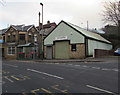
1
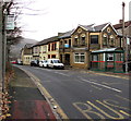
Bridge Street flats, Abercarn
In 2016, number 22 Bridge Street on the left is divided into two flats, 22A and 22B.
The year 1919 is inscribed on top of the doorway.
Image: © Jaggery
Taken: 20 Dec 2016
0.02 miles
2
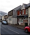
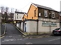
Parkmans office, Abercarn
Property management and insurance specialists at 19 Bridge Street.
Image: © Jaggery
Taken: 20 Dec 2016
0.03 miles
3
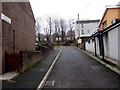
Side road above Bridge Street, Abercarn
The sign on the wall on the left points this way towards Bridge House and Old Royal Oak.
Image: © Jaggery
Taken: 20 Dec 2016
0.03 miles
4
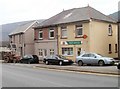
PS Cycles, Bridge Street, Abercarn
The bicycle shop is closed today, a Tuesday. Its Winter opening shown
on the business's website is six days a week. The exception is Tuesday.
Image: © Jaggery
Taken: 20 Dec 2016
0.03 miles
5
Bridge Street bus stops and shelter, Abercarn
In December 2016, the bus stop sign on the left shows N2 to Crumlin, X16 to Abertillery, X18 to Ebbw Vale.
Image: © Jaggery
Taken: 20 Dec 2016
0.03 miles
6
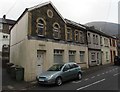
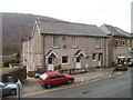
Abercarn Constitutional Club, Abercarn
Viewed across Bridge Street.
Image: © Jaggery
Taken: 20 Dec 2016
0.03 miles
8
The Malt House, Abercarn
Located on High Street next door to the post office. http://www.geograph.org.uk/photo/2303205
A malt house (or maltings) was used to store and prepare malt (barley or other grain prepared for brewing or distilling). The building is now divided into three private residences.
Image: © Jaggery
Taken: 23 Jan 2011
0.03 miles
9
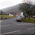
Junction in Abercarn
Bridge Street is ahead and to the left. The road on the right leads to the Prince of Wales Industrial Estate.
Image: © Jaggery
Taken: 20 Dec 2016
0.04 miles
10
Rooftop solar panels, Bridge Street, Abercarn
The houses are opposite the entrance road to Abercarn Industrial Estate. http://www.geograph.org.uk/photo/5233640
Image: © Jaggery
Taken: 20 Dec 2016
0.04 miles