IMAGES TAKEN NEAR TO
Park Road West, NEWPORT, NP11 4RU
Introduction
This page details the photographs taken nearby to Park Road West, NP11 4RU by members of the Geograph project.
The Geograph project started in 2005 with the aim of publishing, organising and preserving representative images for every square kilometre of Great Britain, Ireland and the Isle of Man.

There are currently over 7.5m images from over14,400 individuals and you can help contribute to the project by visiting https://www.geograph.org.uk
Image Map
Images are licensed for reuse under creativecommons.org/licenses/by-sa/2.0
Notes
- Clicking on the map will re-center to the selected point.
- The higher the marker number, the further away the image location is from the centre of the postcode.
Image Listing (29 Images Found)
Images are licensed for reuse under creativecommons.org/licenses/by-sa/2.0
Image
Details
Distance
1
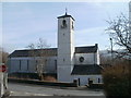
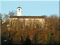
Grade II* listing building, Newbridge
Viewed across Park Road. Shown on maps as Our Lady of Peace Roman Catholic Church, there were no signs at the site to confirm that this is still the case. What is certain is that the Italianate building, dating from the 1930s, has been Grade II* listed since 1999. The attached presbytery (priests' house) http://www.geograph.org.uk/photo/2273746 is included in the listing.
Image: © Jaggery
Taken: 17 Feb 2011
0.03 miles
2
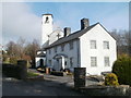
Grade II* listed presbytery, Newbridge
Viewed across Greenfield. The presbytery and adjoining church http://www.geograph.org.uk/photo/2273739 were Grade II* listed in 1999. Shown on maps as Our Lady of Peace Roman Catholic church and presbytery, there were no signs at the site to confirm that this is still the case.
Image: © Jaggery
Taken: 17 Feb 2011
0.03 miles
3
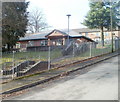
Nursery, Tynewydd Primary School
The nursery building is located on Greenfield, at the northern edge (and highest point) of the primary school http://www.geograph.org.uk/photo/2273660 site.
Image: © Jaggery
Taken: 17 Feb 2011
0.08 miles
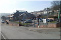
6
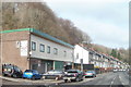
North Road, Newbridge
The view north, towards Crumlin. The road occupies part of the valley of the Ebbw River. It is a narrow band of flat land between hilly terrain to west and east. Just out of shot on the right is the Ebbw Valley railway. The green and white building is Regency Buildings, obviously not named for the style or age of building. It is the premises of Crescent Cars.
Image: © Jaggery
Taken: 17 Feb 2011
0.10 miles
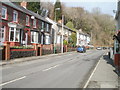
7
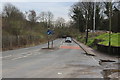
North Road, Newbridge
Looking south along the former A472 after heavy rain.
Image: © M J Roscoe
Taken: 30 Mar 2017
0.12 miles
8
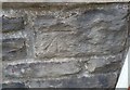
Ordnance Survey Cut Mark
This OS cut mark can be found on the wall of No55 North Road. It marks a point 110.447m above mean sea level.
Image: © Adrian Dust
Taken: 11 May 2019
0.13 miles
9
Tynewydd Primary School, Newbridge
Primary school with about 250 pupils,viewed across a street named Greenfield.
Image: © Jaggery
Taken: 17 Feb 2011
0.14 miles
10
Newbridge : houses near the northern end of North Road
The view north along North Road. The Crumlin border http://www.geograph.org.uk/photo/2297382 is a short distance ahead.
Image: © Jaggery
Taken: 17 Feb 2011
0.15 miles